Thursday, October 21, 2010

Nemrutland

Sunday we drove on to explore a bit of the valley west of Nemrut Dagi, the ruins of the Commagene capital of Arsameia, the 2nd century Roman Cendere Bridge, and the Karakus tumulus. From there we drove on, past Narince, where a major surprise awaited us.

Little remains of the Commagene capital at Arsemaia; they allied themselves 
with the Parthians and not the Romans; big mistake; here, a stele at the city 
entrance, high on a hill


What does remain is fairly great, however: this relief where 
the  Commagene king (Antiochus?) is shaking hands with the
patron god of Heracles; one sees this image elsewhere in the 
period, and it is frightfully close to some sort of divine right 
of kings idea


And this incredible stele about the founding of the city


Late bloomer


Remains of a Hellenistic city


Ditto


And, a few miles around the bend, the 2nd century Roman bridge over the 
Cendere River, a tributary of the Euphrates


Columns on the bridge


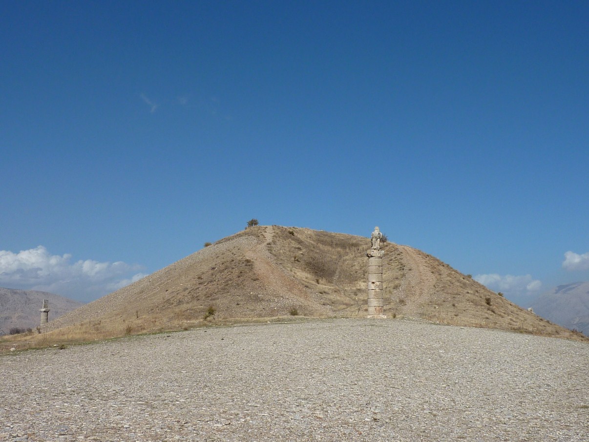
Karakus tumulus, across the valley from Nemrut Dagi; here the female royalty 
of the Commagenes were buried; the Romans plundered it for bridge-building 
materials


Eagle column at Karakus


Other columns, Commagene


Reservoir of the Euphrates


So after seeing all these wonderful sites, we were driving along, making good time, 
but dropping down to the level of the reservoir, when we suddenly found ourselves 
in line to get on the ferry; in this part of Turkey, with the various dams and 
reservoirs and hydro-electric projects, lots of roads have been replaced by ferries; 
upon examination, I determined this ferry was too small and that the seamanship
was dubious (they off-loaded and loaded without ever tying up); we decided to 
back-track 50 miles and stay on dry terra firma


Which took us back through Adiyaman (Ithink) and this interesting view of Turkish 
rug cleaning

Nemrut Dagi

Nemrut Dagi (the "g" is silent but indicates a separation between the vowels: we pronounced it "Nemroot Doggie" nonetheless) is a mountain in eastern Turkey, not particularly high, but above tree-line, upon which the 3rd century BCE Commagene ruler Antiochus built an over-sized setting of statues of the gods, himself included (hopefully). Not just a setting, but two, nearly identical, one facing east, one facing west. Antiochus was deeply into hedging his bets. Above the east and west terraces is a huge 150m artificial mound, which, presumably, contains the remains of Antiochus. Incredibly, the place was not "discovered," until 1881, nor excavated, partially, until 1995.  Over the millenia, earthquakes have tumbled the heads off their seated bodies, but they have been set aright, if not originally, then picuresquely. It is a fascinating place, especially considering the size of the statues and the height and remoteness of the site.

View of Nemrut Dagi; rather than subject the Grey Wanderer
to a high-angle uncertain road, we simply took the maxitaxi
up to the top; well, 600m from the top; the summit cone is
artificial


A view from the top (nearly); it is truly, truly, a harsh land,
all jagged limestone, even worse than what we saw in
southern Spain


A view of the eastern terrace; heads toppled from their
thrones, but set aright below


Me, conferring with the gods


Approximately 1/5 of the world's lady bug population lives
on Nemrut Dagi; seriously


The eastern terrace


Us on the western terrace


On the western terrace


"Hey, mister tambourine man, play a tune for
 me"


Bad leg, bad arm, but she photographs well,
and can go anywhere; and I love her

It's a Long Way to Nemrut Dagi, It's a Long Way To Go

So, having felt we had gotten the gist of Cappadocia, and wanting to see at least a bit of eastern Turkey, we headed out from Goreme, first past Kaseri (Caesuria in ancient times), past the great volcano, hidden in clouds, and further and further east, stopping at a truck stop near Pinarbasi. Because of the lateness of the hour, we missed a great-looking caravansary that I definitely want to see next time. From there, next morning, we swung south, then back east, through Kahrmanmaras, and finally to our goal (as it turned out) of Karadut, at the foot of Nemrut Dagi. Nemrut Dagi (as you surely know) is perhaps the major sight of eastern Turkey, an ancient mountain-top Garden of the Gods, sacred to King Antiochus of the Commagenes, who ruled here in Hellenistic times. But I am getting ahead of the story. Anyhow, it was a day of awful driving, much road construction, unending rain, many delays. We landed at a campground in Karadut simply because we could not drive any further on the muddy roads.

The similarity to the American West is striking,
overwhelming; um, except for the mosques and minarets


Turkish trucks--those owned privately or by small
businesses--are often hand-painted and highly duded-up;
we are envious


Kahramanmaras is the axis mundi of Turkish ice cream,
which is saying something, where the dovme dondurma,
beaten ice cream, was invented; so we stopped for a large
and very satisfying sample


Mado Cafe, east of Kahramanmaras, incredible pastries,
ice cream; very western...


We ascended finally to Karadut; the rain continued;
construction of a new drainage system had narrowed
and muddied the road, and so we pulled off into a
"campground" at the last moment


A day later, the situation looked better; sunny, parked
above a persimmon orchard; the campground (actually the
parking lot of a pension) minimal, but OK for 10YTL


This is not the pretty part of Turkey; the land is harsh; life
is harsh; most transportation is via animal, not car or truck;
the people are mostly Kurds; but welcoming and gentle just
the same


The old-fashioned way

Wednesday, October 20, 2010

Uchisar

After the underground city, we drove back to Uchisar, to see the castle there, and then on to a ridge overlooking Goreme, where we spent our last night in Cappadocia.
Uchisar Castle, another carved-out elevation, perhaps the
grandest of them all


View of Uchisar from the top


Ditto; smaller, vassals' castles below


Us on the summit


For some reason we never understood, the air flotilla
launched again, late in the afternoon, contrary to their 
stated mission of flying only in the early AM; perhaps 
they were moving to their winter quarters in Sarasota


Tourist/native interaction; universal language


Curious cat


Fixer-upper


The more impressive side of Urchisar Castle, over where
the tour buses park; and the bazaar...


At the aforementioned bazaar, world-class kitsch; does
UNESCO have a category for this?


Another photo pregnant with meaning: a
Japanese tour bus has just rolled in, joining
the dozen others, I am up on a mound hoping
to capture the drama, the excitement, the 
beauty...the balloons are launching in the
valley, the camel is waiting for his next trick,
and Vicki is laughing hysterically at me and
the whole Cappadocian scene


Anyhow, we parked that night with a couple French RVs
on a ridge overlooking Goreme; they were just back from
Syria


And had lunch the next day, exploring Goreme, at a
"traditional" restaurant called A la Turca; the mezes...


And the main, sort of a sliced roast beef (?),
smoked, served on a bed of frites, smothered
in yogurt and brown gravy; I swear I am
not making this up; credit Vicki for not even
thinking of asking for ketchup; so far as I
know

Tuesday, October 19, 2010

Kaymakli Underground City

In addition to all its other attractions, Cappadocia also has several underground cities--places where the Christian or other communities could literally go underground and live for a time while marauding or crusading armies marched through. We chose Kaymakli, which had eight levels, four of which are now open. It accommodated 3,000. Derinkulu, nearby, could accommodate 10,000, they say.
Rather than being underground, strictly speaking, Kaymakli was built into this 
ridge 


Tourist entrance to Kaymakli


Whatever; it's another World Heritage Site


Looking down one of the corridors


It was reasonably well signed, but we engaged a guide anyway--the guidebooks 
said to--for a mere $15 we got to hear, three times, how the citizens of Kaymakli 
solved their "toilet problems"


For defense, or if the neighbors wouldn't turn down the music, the citizens 
could close off passages by rolling these really heavy stones into place


Vicki in one of the smaller passage-ways; not a place for 
claustrophobes


Flat-screen TV would have been very popular; but then all the satellite dishes would 
have given away the location of the city


In the (common) kitchen area, our guide said, this was the spice rack


All in all, I did not think the underground city was all that 
great; I later amused myself in the adjoining bazaar