After a brief but costly stop at Dale's of Norway's sweater outlet shoppe in Dale, we drove on in to Bergen, Norway's second largest city, and lucked out with a parking spot just a block from the harbor, the Brygge and the Maria Kirke. We missed the English language walking tour, unfortunately, but decided we'd just do it ourselves. Pretty much everything of interest in Bergen is within walking distance of the harbor. Of particular interest were the Brygge houses, 18th century German merchant homes and business, mostly conserved and not restored. Some are pretty rickety, but all are in the gentrification process. It's another World Heritage Site. Bergen was a major Hanseatic League capital, and indeed capital of Norway briefly in the late middle ages, so there is all that (yawn) Hanseatic history. The harbor also features the fish market, which indeed had some fish, in addition to the usual tourist trinketry. The fishmongers were generous with free samples, and I managed to down a fair amount of salmon, cod, shrimp, and—a first for me—smoked whale. (Does not taste “fishy”). Also some more reindeer and moose sausage. All in all, the fish market was disappointing, more touristy than fish. We walked about the sentrum area, saw the Maria church (oldest building in Bergen), the most completely littered junk store I have ever seen, and then did some internet. It was cloudy and gray, threatening rain, so we decided to forego the highly recommended funicular for the view from up the hill. Somehow, Bergen did not send us. We proceeded on, after dinner, up the E39, across the Osterfjord, to Oppedal, on the Sognefjord, at a beautiful rest area, where we'll catch another ferry Tuesday morning. *would make a great name for an 80s Bergen rock group

Ground zero Bergen, especially the turbuss

At the fish market, Norwegian caviar, not bad

Smoked whale; about $30/lb; does not taste "fishy"

Brygge, the old Hanseatic German quarter

Vicki en route to the Christmas shoppe; the stairs eventually got her there
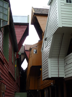
Brygge back alley

Ditto

Maria church, oldest building in Bergen, they said, 13th century

City Hall and square


