Saturday, July 17, 2010

Eigernordwand 3

More scenes from my Eigernordwand walk...
The trail, further on; lots of people, some
hiking up, most hiking down; it's a relatively new
trail


The north face is too angular to hold much snow or ice, but
there are some snow fields and dozens of waterfalls on the
lowest cliffs


Another, closer up


Another


Cutting some interesting deep clefts in the
limestone


Ditto


And at last we're back down, near Alpigen and
the train ride back 


Random Oberland scenery from the train


And back in Grindelwald


Vicki spent the day favoring her knee, reading, and doing the wash. I owe her yet another one.

Eigernordwand 2

It was a good day for hiking. Under the north face, however, it is a bit tricky to guess the right time to be there and see what you want to see: increasing valley haze, clouds, position of the sun and shadows, and so on, are all complicating factors. Part of the north face phenomenon, in this hemisphere, is that they get little or no direct sunlight. So in July, you're staring up into the sun, trying to see a 5,000 foot face that's in the shade. With the angle, foreshortening of perspective, other things, it can be frustrating. But still pretty neat...
Part of the station at Eigergletscher...enlarge to see the cogs
on the middle tracks


Closer up of Eiger glacier


Rounding a bend as the trail begins, you get
sort of a profile view closer up


Your can see the trail, upper right, and the terrain, which
was pretty easy


Looking toward the summit betwixt two
huge pinnacles


Below, the crossroads of Kleine Scheidegg


Play of shadow, angle, light, somewhere
below the north face


Round another bend and you're below the
"direct" area of the north face climbs, with
this helpful sign depicting some of the
classic attempts/routes; the box shows the
position of the Eigerwand train station,
inside the mountain, where you actually stop,
get out, go look out the big windows; the
weisse spinne above is the famous White
Spider, which conveniently funnels all the
avalanche and rock fall above onto the
north face routes; the sign well conveys
the concave nature of the whole face; in the
30s they called it all the "Mordwand"; the
north face is mostly climbed in the winter
nowadays


Artsy-fartsy attempt...


Grindelwald and valley below; and the Weisshorn


Another summit-ward view


Clumps of tiny Alpine flowers everywhere

Friday, July 16, 2010

Eigernordwand 1

Thursday the clouds hung low over the mountains and valley, and, apart from a few reconnoitering walks, we did not do much. Friday I was up early to hop the 8:17 train out of Grindelwald up to Kleine Scheidegg. From there I walked up to Eigergletscher and began my crossing of the Eigernordwand, the Eiger North Face, albeit on a trail, generally on the 7,000 foot contour, above tree-line and just below the the first bands of cliffs.
Early morning prospects for a good day


The Hotel Bellvue, at Kleine Scheidegg, from which, in
the 1930s, tourists could watch attempts on the
Eigernordwand; I stopped for coffee and a look around


The Jungfraujoch--the saddle between the Monch and the
Jungfrau; on the left is the "Sphinx", the observatory/train
station...the Jungfraubahn takes you from Kleine
Scheidegg up into the Eiger, with a stop on the North Face
itself, then back through the Monch and to this station (we
did this years ago with the girls); the Jungfrau summit is on
the right


By 9:45, the Junfraujoch was clouding up; pity all the
hundreds of people who paid $100 a piece for the view
from "The Top of Europe" this morning


Swiss ingenuity: no tarn where you need one? Just build
your own!


Profile of Eigernordwand, way below the
Eigergletscher


From the Eigergletscher moraine, looking
across the Lauterbrunnen Valley--which is
so far down in the hole you can't see it;
among the cliffs are the Staubbach, the
famous waterfall, the village of Murren on
top, and, above right, in another cloud, the
Schilthorn, which I climbed Monday


A marmot on a rock just below the Eigergletscher


Off the Jungfrau, a flock of Crebain out of Dunland; no,
wait, that's New Zealand; or the Misty Mountains; or ...


Looking across the Eiger glacier to the
summit of the Monch

Wednesday, July 14, 2010

Lazy Day in Grindelwald

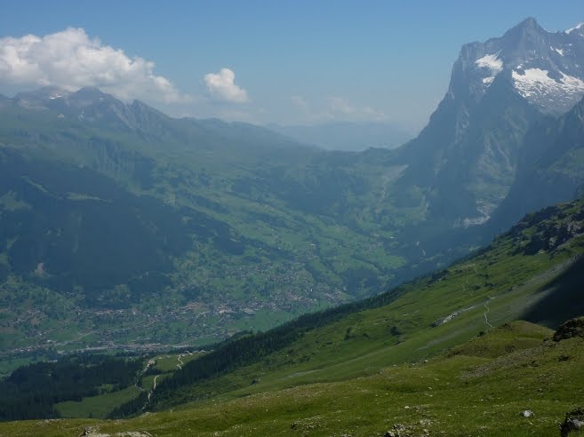
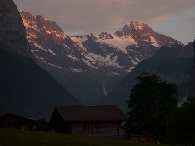
Tuesday we moved from Lauterbrunnen to Grindelwald. Pullling up stakes and driving the 20km took a good part of the day, as did finding and setting up camp at the Gletscherdorf campground in which we are now parked. It is by a glacial torrent, coming down from the Shreckhorn and its glacier, right at the northeast base of the Eiger. We have sort of an angular view of the Eigerwand. The Finsteraarhorn, the tallest of the Berner Oberland group, is just above the aforementioned glacier. We had seen and done the things we wanted to do in Lauterbrunnen, and I had tired of the $wiss anal greed on such spectacular display at the $hitzenbach campground. They charge for garbage, hot water for diswashing, showers,  wifi, etc. Where we are now is about the same price, but everything is included, even wifi. Luxury! And a pleasant and helpful staff too, unlike Shitzenback and Ms. Piggy there. And no tour busses of US and UK college students. But I digress.

Wednesday we resolved to do nothing, and then to rest. We accomplished this by walking into Grindelwald, a quarter of a mile perhaps, doing some grocery and window shopping, and then returning to the campground for a warm afternoon of reading, resting, and internetting under our awning. For dinner we enjoyed a salad and cheese fondue. Gruyere and Emmentaler, bought in the right places, and Kirsch, etc. Probably not many others were doing fondue this evening--we usually do it for Xmas--but we have our customs and traditions to uphold: when in the Berner Oberland, eat cheese fondue, no matter if it's 93 degrees outside. The chocolate course, with Caillier's, bananas and strawberries, is later this evening.

Oh, and Happy Bastille Day, y'all!

In Grindelwald, the Eiger on the right


The Finsteraarhorn, I think, is the one of the right; maybe
the left...


A 1930s tri-motor flies over the Eiger summit


Main street, Grindelwald


One of the world's more scenic putt-putt courses


They do parasailing here too, though not as profigately as
in Chamonix


Evidently Victorinox makes Swiss Army parasails; also
peels potatoes and adjusts valves on Porsches; and
downloads 8G for presentations


Making hay, the old-fashioned way; you have to admire
their work ethic...


Vicki's new camper-sized fondue pot for two

Tuesday, July 13, 2010

Ascent of the Schilthorn

Monday I climbed the Schilthorn, 10,000-something feet, partly for nostalgia (I had done it in 1979 or 1986, can't remember), partly for the view of the Berner Oberland. I took the cable-car from Lauterbrunnen to Murren, from 2,600 to 5,300 feet, then walked the rest of the way, via the PanoramaWeg. It was the most walking/climbing I have done in a while, but entirely worth it. Vicki spent several hours walking the valley.
The night before, alpenglow on the Breithorn


On the trail the next morning, in cow
country; international language for
electrified fence


Alpine flowers in full riot-gear


Lunch-time view from the trail: the three amigos, Eiger,
Monch, and Jungfrau


Another thousand feet, Piz Gloria, the Schilthorn


Setting for an early Bond movie, On Her Majesty's Secret
Service; George Lazenby as Bond, not Indiana Jones' dad


UNESCO-approved view of the three, from Schilthorn,
and the "village" of Murren below


Breithorn from Schilthorn


Famous sign on the razor-edge trail


Justified, too


Big mountains make their own weather: all
afternoon a killer cloud had clung to the north
face of the Eiger

On To Switzerland

After grocery shopping Saturday in Sallanches and a quiet, drizzly, evening at the Aire de la Fontaigne, near Les Houches, we drove on up the Chamonix valley, bidding reluctant farewell to France and the Pays du Mont Blanc. We stopped at the Col du Forclasz, where we spent one of the more memorable evenings on the TMB in 2005. It had been a long day, starting in Champex, Switzerland, involved picking bilberries, stopping at a mountainside cafe for refreshments, a very long walk, marveling at how far Martigny was below us (a very deep canyon it sits in), another mountainside stop at Bovine, Switzerland, for more refreshments, and then, as heavy rain began falling, the stop at the campground at Col du Forclasz. A couple from Burgundy we had been leap-frogging (nyuk-nyuk-nyuk) all through the TMB helped us set up our tent and shared their hot water for our delicious freeze-dried trekker meal. The next morning--3 days' rain were forecast--we followed them and their advice, hopping a train to the French border, then a French train on down the valley, stopping at Les Houches for a motel night, then moving back to Chamonix as our base for drying out, and then continuing the trek. Kindness of strangers. We ran into them again at Praz Plan a couple days later, back on the TMB, and returned the favor, giving them all our water...they were tenting up high, and dry, and we were heading back down. Speak, Memory.
Col du Forclasz; the campground, such as it was, is just
behind the restaurant


Vicki by the TMB signpost at Col du
Forclasz


The old fortress in Martigny; not one of Switzerland's
prettiest towns


We stopped to walk through a Sunday market at Col du
Mosses...


And drove through much charming Swiss countryside
before landing finally at a campground in Lauterbrunnen;
that's the Breithorn behind the camper