Sunday, January 18, 2009

Travails of the Ringer


On (exactly) this site, in the year 3147 of the Third Age, Rangers of Ithilien attacked and annihilated a large Haradrim force, including two battle oliphants; the Rangers were led by Captain Faramir, son of Denethor II, Steward of Gondor... (and on the cliff to Vicki's right (out of view; but we were there) Sam and Smeagol argued about proper preparation of a brace of coneys)

These are the kinds of challenges and obstacles with which the faithful Ringer must contend...

We got as far as Lothlorien...

And even to Isengard; OK, lose the fence and powerline and the sheep, and CG-in Orthanc...

But, obviously, we didn't get as far as Paradise; the seventh ford was too deep and fast, and I almost over-turned the Bongo backing away; but some friendly Kiwis (from HireEquip) pulled us out and saved the day.

In addition to the above items, at 12 Mile Creek, further up Lake Wakitipu, to Glenorchy and beyond (almost Paradise), we also did a long day hike on the Routeburn Tramp, which we'll do fully in ten days. It was raining for most of the hike, so there are not many pix.

It's Sunday night and we're back in Queenstown, leaving for Te Anau and preparations for the Milford Tramp Monday morning.

Thursday, January 15, 2009

Atop the Remarkables

Thursday again combined the mundane with the exceptional. After more morning errands, we drove up the 13km unsealed track to the Remarkables Ski Center and then hiked up to Lake Alta, a glacial tarn near the end of the range. The views back toward the lake and town, and beyond to the Southern Alps in the great distance, were terrific. At Lake Alta, we identified two important LOTR sites, another Dimrill Dale view and also the creek (actually a smaller pondlet) where Aragorn crosses the Silverlode (so Vicki said). The exciting descent featured more views and also a para-sail launch site. The later afternoon and evening were occupied with washing sleeping bags and other things, and a mundane camper meal prepared in the campground kitchen.

Friday we'll leave Queenstown and spend a few days in the Glenorchy area, reconnoitering the Routeburn and hiking. The Milford tramp is next week.


Southern Alps, Many Miles Away

Peter Jackson and Viggo Mortensen Stood Right Here!

Same Dimrill Dale, Different Island

These People Will Jump Off Anything...

Two Views of Queenstown


The Great Elven Gate at the Entrance to Queenstown Hill: "Speak, Friend, and Enter"

Queenstown and Lake View

Most Mushrooms Are Drab and Uninteresting; Not in New Zealand--Pizza Mushrooms!

Dinner with a View

Our Wednesday morning hike was up Queenstown Hill, 1800 meters, with fine views of the lake and town. Queenstown actually wraps around the lake a bit; the lake itself is sort of S-shaped. So, except from high above, it's not possible for a camera to take in the whole thing. The loop track we took led us through a dark forest brimming with the most unusual (poisonous) mushrooms (see illustration). In the afternoon we did some errands, store-bought haircuts, repair (second time) of my lousy Vasque boots, miscellaneous shopping and returns and exploring in town. For dinner, we took the cable-car back up Ben Lomond to the Sky Center, where, following luge rides, we had the excellent buffet dinner, 8:15 seating, corner window for two, best in the house.

Wednesday, January 14, 2009

Cottage-on-Wheels Industry


Ace, Wicked, HappyCampers, GoBirdz, Kea, Kiwicampas, Jucy, Maui, United Campervans, Discover NZ, Apollo, Britz, Camping Cruzas, CheapaCampas, Spaceships, Backpacker, Tui....

These are a few of the campervan rental brands parked at the campground we are at in Queenstown. I won't attempt to generalize about how Kiwis do their holiday/recreational travel, but it seems like every 3rd or 4th vehicle one sees here is a rental campervan, generally a class B or class C rig. The terrain and roads argue against the big American class A's, of which we have seen none in our month here; which is fine with us. My favorites are the minimalist Wicked campers, all attractively and imaginatively (some would say distatstefully) painted up. One just pulled by that had huge letters on the back that said “Hold Still—I Have Very Poor Depth Perception.”

Queenstown Advertising


Tuesday morning we hiked up to the Sky Center on the mountain behind us, Ben Lomond, a good 1500 feet up and back down, mostly on a good track. At the Sky Center were an ample observation deck (incredible views of Lake Wakatipu, Queenstown, the Remarkables, etc), a restaurant, gift shop, para-sailing, luge, and the obligatory bungy jump (also AJ Hackett's). We had a scone and a savory muffin and the pictured cup of latte, which, though visually appealing, wasn't all that great. They also sold pasties (not pictured). The Remarkables are a range of craggy peaks south of the lake, Queenstown's frontal view. More of them later.

For dinner, we did fish n' chips for me, popcorn for Vicki at the movie, "Australia." I liked it (more than "Twilight"); Vicki didn't.

On to Queenstown

Queenstown is the adventure tourism capital of the South Island, maybe New Zealand, probably the world. Ever wanted to wing-walk a stunt bi-plane? You can do it here, as well as anything else you or anyone else has been able to conjure up. Apparently Kiwis are not particularly litigious. Or perhaps their judges and juries are not particularly sympathetic to people whose claims involve jumping off of towers, bridges, canyon cliffs, buildings, aircraft, tall trees, etc.

Apart from several LOTR sites en route (more later), our major stop of the day was at the old Kawarau River Bridge (over the Anduin, again), where bungy (sic) jumping was invented and perfected by one AJ Hackett. There are higher sites (also Hackett's) and more outrageous jumps, but this one was the original, very historic, founded way back in 1988 (AD). And, since we were driving right past it, in search of the Pillars of the Kings, we had to stop. It's not just a rope hanging off a bridge. There is a visitor center, an historic plaque, a multi-media show, a gift store, a wine bar/cafe, a restaurant, wine-tasting...and, oh yes, scores of people lined up to jump in an assembly-line procession, family and “friends” encouraging them from the sidelines. I was very slightly tempted, but unfortunately, or not, had shot my whole adventure tourism budget on the micro-flight. The oldest person to have done this sort of thing so far was 94. I'll come back later.

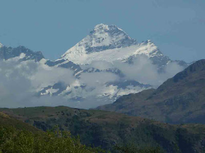
The day's LOTR sites included a variety of panoramic views, in Rob Roy valley (Misty Mountains south of Rivendell), in the mountains south of Wanaka, the Crown Range, and on the river by AJ Hackett's, the Anduin, again, which must be a great river indeed since it spans two islands. In the case of the latter, the search involved a stop, a tasting, and, ultimately, a purchase at the Chard Farm Vinyard, whose staff were very knowledgeable of Ring lore and local sites, and who produce a very fine NZ sauvignon blanc. This is the price faithful Ringers must pay. The last sites were in Arrowtown, a beautifully restored/preserved mining town that was crawling with tourists on a sunny Monday afternoon. The sites in question were two river shots, the Ford of Bruinen, where Arwen saves Frodo from the Black Riders (in the movie), the other the Gladden Fields (ditto) where Isuldur was ambushed by the orcs and lost the Ring. (I can't believe I am writing this stuff; Vicki is the Ringer in our crew). In any case, we found both fairly readily, for once, enjoyed some time on the river and in town, and then moved on to beautiful Queenstown, a small city on a huge high lake, ringed by tall mountains. We camped at the Queenstown Lakeview Holiday Park, a few blocks up from the downtown.


Natural Selection in Progress; at AJ Hackett's Original Bungy Site, Kawarau (Anduin) Bridge

Vicki at the Ford of Bruinen

The Mighty Anduin, The Great River, from the Chard Farm Vineyards

January 12, 2000--Arrowtown, near Queenstown, New Zealand

We stayed last night in our first "wild camping" at the end of a day hike into a fabulous canyon with Rob Roy Glacier at the end of it. Basically we haven't wild camped as much as we thought we would. Part of that is being strangers in a strange land, but also because of the sand flies. These are terrible in rural areas with lots of grass and bushes. It was very windy last night so they weren't a problem, but they were back this morning, so we packed up as quickly as possible. Today we drove to some additional LOR sites on our way to Queenstown. We are in the public library now--we had to pay (though only $1) to check email, so I thought I would use the rest of the time to blog. We did stay two nights in a backpacker's lodge in Wanaka and were very pleased with it. It was only $36 a night whereas camping without hookups would have been $18. We had our own room and the bath was down the hall. It was nice to be inside--the kitchen had everything including a blender, dishes, even special shelves in cupboard and refrigerator labeled with your room number. We spent more to rent a van we could sleep in, but had we known how great and easy the backpacker accomodations were, we might have gone with just a car and ended up paying about the same in total per day. We still hope to come back in the next few years for 4-6 months. I know we won't do the van route as we can barely climb up into the roof bed now! We are starting to think about buying the camper for Europe so that is exciting, too. I am also excited about getting back to Missoula for visits with our friends--whom I miss very much.

Kiwi Signage

Vicki and I love signage. Our house in Missoula featured sign forests all over, and we're still “collecting.” Kiwi signage is some of the best, at least from my peculiar perspective.

Men's Room ("Gents")

More Bathroom Humor

Department of Conservation Tramps and Hikes Are Very Well Signed

If Somewhat Understated

Keas Are Another Feature of the Gondwanalandian/Zealandian Flora and Fauna Here; They Are the World's Only Alpine Parrot (and Large Enough to Kill a Sheep); We Have Seen None--They Are All Evidently Over in Fiordland, Not Pining; Apparently German and Japanese Tourists Can't Resist Feeding Them

Schist Is Everywhere Here

Rob Roy


Mt. Aspiring; I think

Part of Rob Roy Valley; Click to Englarge and See If You Can Count All 57 Waterfalls in View; Bonus Question: Elaborate a Defensible Principle of Individuation for Waterfalls

Part of Rob Roy Glacier

Another Part: Need a Bigger Lens!

On the advice of some experienced senior trampers at the Altamont, we drove the 80km west and north of Wanaka (last half unsealed, with six fords) into the Mt. Aspiring NP to do the Rob Roy glacier day hike, out of the Raspberry Creek carpark. The hike took 4-5 hours and was exceptional, certainly the best day hike we have ever done. The trail climbed about a thousand feet, very gradually, through a canyon and then beautiful beech and fern forests, with ongoing views of Aspiring, Rob Roy, the glaciers, and the Rob Roy valley, whose walls featured more high waterfalls than I have ever seen before. The Rob Roy glacier hangs above the trail's terminus, and stretches a great distance. Dozens, scores, of great waterfalls plummet from the glacier and onto the cliffs below. We have seen many glaciers and glacial features, but never one so well put together, scenically, as this.

We got back to the Bongo about 6PM and resolved to “camp” in the carpark...too tired to move on, too enthralled with the surroundings, a really, really special place. (Camping in our case consist of putting up the roof). The Rob Roy valley must cover 60-75 square miles, most of it beautiful well-watered sheep and cattle country. The surrounding mountains are incredible. And Aspiring is at the head of the valley, overlooking it all.

Wanaka in a Day

Well, we did not actually do Wanaka, so to speak, although our stay there, at the Altamont Lodge, was pretty satisfactory. Our morning included blogging, computer and photo maintenance, and the usual hand-washing of our few garments. In the afternoon we walked into town, 2 km, to avail ourselves of the free public library wifi only to find Wanaka is the only library we so far have encountered on the island that does not offer this service. So, after a stint at the cyber-cafe, we walked back to the lodge, taking in the manifold local activities at the parks around the lake: an antique auto show, farmers market, cricket, boating, para-sailing, and the rest. Wanaka is a happening place, said to be sort of a small auxiliary Queenstown. The terrain, from a distance, reminds me much of Montana. Mt. Aspiring and its glaciers and snow summit are off in the distance above Lake Wanaka. My only regret in visiting this place is that the we did not stay at the other backpacker lodge, the Wanakabackapacka.

Lucky Montana's Flying Circus (Para-sailing) Operates from the Shore at Lake Wanaka; a Speed Boat Pulls you Aloft, Hopefully Before Your Feet Get Wet Vicki Wantewd To Ask Lucky Where in Montana He Was From, But He Was Busy With a Young Client My Question Is, If They All Wear White, How Can You Tell the "Yankees" from the "Dodgers"? Lake Wanaka...About the Size of Flathead Lake, I'd Guess 

Friday, January 9, 2009

Rain from Hasst to Wanaka


Rain at Lake Hawea

On the Hasst Highway

Headlands Bluff, Near Hasst

Just before Hasst, heading south, one encounters what must be the world's longest one-lane bridge, perhaps the better part of a kilometer, with two “passing bays,” just in case you meet another vehicle. (The train track does not go this far south). The bridge crosses the Hasst River, which drains many mountains and valleys east of here, just before it meets the sea. The whole area is replete with geological features of earlier times, when the glaciers came right down to the sea.

From Hasst, the road turns east and follows the river up into the mountains to Hasst Pass. We did all this in the continuing rain, stopping occasionally to walk back to a waterfall viewpoint or some other feature. Lots of waterfalls in this terrain. The vegetation also changes, the fern trees and such giving way to the alpine (more properly, montane) flora to which we are more accustomed. Still richly forested, big trees, but not so dense and impenetrable as the bush.

Beyond the pass, one enters into a sort of lake country, now in or near the Mount Aspiring National Park. These are high, enormous lakes, remnants from the ice ages, many miles long and presumably very deep. We spent an hour or more driving past Lake Wanaka and then Lake Hawea. One of the photos shows Lake Hawea. Note rain.

At length, we arrived in the tourist town of Wanaka, on the edge of Mt. Aspiring NP, and decided to hold up here, at a “backpacker” lodge, for a few days, regrouping, hiking, etc.

Note on accommodations. Since Australia, we have noted the prevalence of “backpacker” accommodations everywhere. We have stayed at many, including the holiday parks. Essentially, they offer a range of accommodations, everything from a tent-site to en suite rooms, with a commons area including ample kitchen, appliances, utentsils, dishes, etc. The place we are at in Wanaka even has its own bar-ware. These accommodations may seem favored by the younger, gap-year set, but not really. There are always families, people our age (or nearly so), trekkers and trampers, all sorts of nationalities. It's a great way to travel, affordable, and a great way to meet others of like interests.

Don't Go Too Near the Glaciers

Beginning around Greymouth, on the coast, the land begins to change. Everything turns grey, the rock, the rivers, etc. The weather also turned grey. The sunny weather we have enjoyed, even in the rain forests, is over for a while. It is cloudy and raining intermittently. Looking at the map, we know that to our east are the Southern Alps, not particularly high mountains, but high enough to be intensely glaciated. The area around here receives about 5m of rain a year. Yes, 5 meters. Higher up, that means tons of snow, ice, glaciers, and glacial milk in the streams and rivers. 

Before turning east into the mountains, however, the road continues further south to Hokitika (“Hoki”), a small but picturesque enclave of artisans and craftspersons. We spent a few hours looking at the shops, particularly the jade and wood shops. Jade is all over the west side of the island, and the Maori used it extensively for all kinds of practical and ceremonial purposes. Hoki also features the Hokitika Sock Machine Museum, where one may not only view sock manufacturing machines of the past but also purchase fine socks, many manufactured locally. See illustration for evidence I am not making this up. No one could make this up. 

We proceeded on, now more easterly toward our goal for the day, the Franz Josef and Fox glaciers, relatively massive glaciers coming down from Mt. Cook & friends. At their height, they came nearly to the sea, but, we are now (for the last 10,000 years or so) in an age of glacial retreat. We took in the visitor center at the Franz Josef, drove out to see it, but decided it would be better to do our daily walk at the Fox glacier, a few more km south. We also theorized it might not be raining at the Fox. We did indeed walk out to near the edge of the Fox. Just a second before the picture below was snapped, the glacier calved—a shocking roar and then a splash nearly as high at the glacier itself. We had seen calving before, at Glacier Bay in Alaska and also in the Alps, but never anything quite so large as this one. You can see some of the debris in the lower right of the photo. Half an hour later, as we walked closer to the farthest viewpoint on the trail, we heard that two persons had been killed in the incident we had earlier witnessed from far away. Park rescue and recovery staff began passing us en route to the scene. We learned later that two Australian men, in their 20s, had ventured well beyond the authorized viewpoint and were indeed killed. In the news coverage, a Park official noted that “people just love to touch the ice.” The last photo above is of some of the debris as it washed pass us in the river. 

We drove on, further south, ever more grey, and camped at another holiday park, taking advantage of the kitchen and dining room facilities. Vicki fixed chicken cordon-bleu, and we spent much of the evening chatting with Kiwis from Palmerston North, en route to tramps in the south, as we are. Palmerston North is a sister city of our hometown, Missoula.

 Hokitika's World-Famous Museum of Sock Manufacturing      
Glacier meets the jungle: the Franz Josef Glacier
The Fox Glacier, just after a tragedy


Calving debris

Give Way


One of the South Island's many charms is the custom of occasionally combining railroad with auto/truck bridges. The bridges are mostly one lane anyway (regardless of length; sometimes hundreds of meters), population is sparse, traffic is light, so, what the hey, why not have trains and cars and trucks share the same bridge?

Here, south of Greymouth, as on all other New Zealand RR crossings, motorists are helpfully reminded that trains have the right of way.

Heaphy to Pancakes

Tuesday morning we hiked a few miles of the Heaphy Track, which begins at the campground, up through the bush to Scott's Overlook and Scott's Beach. From that point, the Heaphy turns inland and proceeds more or less east the rest of its length, some 82km. No water taxis on this tramp. I can't imagine trying to land anything in the Tasman surf we have seen.

We are trying to walk a bit every day in preparation for our next tramp, the Milford, in two weeks, way down south, much more strenuous than the Abel Tasman. After the walk, we drove south, back to Westport, visiting the public library there and its free internet, and then still further south on route 6, which is sometimes along the largely uninhabited coast and sometimes in the also largely uninhabited inland bush. En route we stopped for the “Pancakes and Blowholes” site, a major attraction, giant fractured cliffs of thinly-layered limestone jutting out into the sea, wonderfully sculpted, and featuring enormous sink-hole-like affairs through which the crashing sea blows and spouts during high tide. We were there at low tide, so did not see the full effect. It was most impressive, nonetheless. At the DOC visitor center we found what has to be one of the better t-shirts of the trip, with the “not all who wander are lost” quote from Tolkien. Really ties things together, especially here in NZ.

We camped at the Top 10 in Greymouth, stopping early so Vicki could fabricate and install mosquito netting in the Bongo penthouse, where we sleep. I steamed mussels for dinner; again.

The Road Does Not Go Ever On From Here, North of Karamea

Irimahuwhuero, Along the West Coast Between Westport and Greymouth

Pancakes and Blowholes