Tuesday, July 14, 2009

Leaving Geiranger


Dining al fresco, like European campers do; our German neighbors approved of the currywurst, rotbet, bier, etc.

A big ship parked right next door and blocked our view

But Vicki got some good pix of the mooring; then we left

Fiord ponies visited the Grey Wanderer at our next stop; not exactly Shadowfax

Geriangerfjord from the Ornevegen summit

Us at Ornevegen

Vicki adds:

July 10, 2009 Geiranger, Norway


The past few days we have driven through the fiord area and it has been wonderful. Last night though as we drove to the top of Djupvasshytta (quite a mouthful) at about 5,000 ft the whiteout moved in. We had followed 5 tour buses to top of a steep, winding toll road and we were determined to wait for the view to clear. Which it did, at least for a few minutes, and it was magnificent as you could see all the way down to the fiord at sea level. I was unwilling to drive back down in the whiteout so we stayed the night and gave up waiting for the clouds to lift at 10 this morning. I decided to stay in the back of the camper and read on the way down as my nerves are shot. I can deal with winding roads, steep roads, drop offs with no guard rails. What I can't deal with is one lane winding, steep roads with two way traffic including tour buses! The tunnels have also been interesting as we have probably passed through over a hundred in the last 3 days, some as long as 6 miles. They are not normal tunnels—they have s curves, they go up (10% grade), they go down (8% grade) and they also can be 1 lane with two way traffic—and none of them have lights. So my nerves are a bit frazzled and I keep demanding Mark not to go over 10 mph. We are now at a campground at the end of the fiord and will wait for tomorrow to take the sightseeing cruise and then the Eagle's Road up the mountain as the weather is supposed to be better.


Right now outside our window is a huge cruise ship. Cruising the fiords is very popular and great for people who can't get around very well as you can see all the beauty from the deck. I talked to a man from San Diego who was on a 7 day cruise through 7 fiords and they were loving it. I have no idea what that costs but given the prices of rooms and food here, it is probably cheaper than doing it by car. Write to me. Vicki

Geirangerfjord Cruise

Sunday we did the brief Geriangerfjord cruise; Dalsnippa is
the mountain, way back in the middle, where we spent the night


It was the economy cruise
Geirangerfjord view

Seven Sisters waterfall; let's see, Sleepy, Grumpy, Sneezy

The main Storfjord, of which the Geriangerfjord is an arm


Maids of the Mist, Norwegian fjord ferry
And old fiord farmstead; these are being restored, making
Geriangerfjord another World Heritage site


Saturday, July 11, 2009

Another Reason to Like Ferries


In this amazing sequence, a Norwegian fiord ferry actually
devours a tour bus

Munch, munch, crunch

You could hear the passengers screaming all the way
across the fjord

OK, it was a very slow day in Geiranger.

Geirangerfjord

Geiranger on the Geirangerfjord; we drove down the mountain, still in a 
white-out, Friday mid-morning, slowly, deliberately, in 1st gear all the way, 
then stopped at Camping Geiranger, right on the fiord


It rained the rest of Friday and was cloudy enough Saturday  to discourage the 
fiord cruise, so we spent the day cleaning  the camper, doing chores, etc.
Grey Wanderer is smack in the middle


About all there is to do in Geiranger is watch the cruise ships come and go
Some debark and stay a while, some just turn around and  leave for the next fjord


Me fjishing in the fjord; actually, me instructing Vicki on framing the shot to 
include my head, fishing pole, fjord,  etc; she was laughing so hard I am 
surprised the picture is in focus; so confident is she of my fishing skill that she 
has promised to gut, clean, cook, and eat any fish I catch


Inscription on an RV parked near us: "Dream not your life, 
live your dream"

Friday, July 10, 2009

More Mountains and More Glaciers: Briksdalbreen and Dalsnibba

We detoured again today, driving up the Olden valley, past beautiful high lakes, mountains, glaciers, waterfalls all around, to the Briksdalbreen, the Briksal glacier. It's a 4km hike up from the carpark. I'm beginning to think of the Jostedalsbreen, the big glacier, as rather an ice field, like the Columbia Ice Field in Banff/Jasper National Parks, in Canada, that covers many square miles, feeds three oceans, and has many glacial outlets. The Briksdalbreen is such an outlet of the Jostedalsbreen, I gather; there were three or four other outlets within the immediate vicinity. Interestingly, glaciologists say now that the Jostedalsbreen had completely melted away 8,000-10,000 years ago, and that all its growth, especially in the mini-Ice Age of the mid-18th century, has been relatively recent. The Briskal glacier reached its greatest extent in 1996-97, but has receded somewhat since then. Micro-climates, they say.

The Briksal glacier, in any case, is large enough, the tongue fairly angular. We walked to within half a kilometer of it, snapped some pix, stopped, and had lunch. I guess our experience in New Zealand, seeing a calving that killed two men, has made us a bit glacier-shy. Plenty of people are not, however. “People just love to touch the ice,” as the Kiwi park ranger said.

We drove back to Olden, then Styrn, and set forth on the “Golden Route,” the alpine road that links our next goal, Geiranger and Geiranger Fiord, with its north and south neighbors. It is a beautiful wide road, with several long (4-5km) tunnels, that winds up into some high and desolate alpine scenery. We got as far as the toll road up the Dalsnippa, a 1500m peak, and decided to follow the tour buses up it. The road was OK, if quite exposed. We entered a white-out several hundred feet from the summit, and resolved to park at the summit until the clouds lifted. We (Vicki) did not want to drive down in the white-out; and we wanted our 80 kroners worth of scenery!

The clouds did lift temporarily about 7PM, and we had some fine views of surrounding peaks, Geiranger and Geiranger Fiord, 1500m below. A big cruise ship was leaving Geiranger. Interestingly, or not, there are six of us parked here at the summit, for the night. At least it should be quiet.

Mountains, glaciers, waterfalls...everywhere

Me at the National Park boundary

Briksdal glacier

Up closer; click to enlarge and see them touching the ice

Atop Dalsnibba, cairns everywhere

Geiranger and Geirangerfjord from Dalsnibba

Up closer of the cruise ship leaving

Proof...

...that the Norwegian Department of Transportation is fabricating neolithic sites...
this one a dolmen
Or maybe another picnic table?

Vagsoy, Maloy

Quaint little Norwegian fishing village...well, that's what we were expecting. Instead, Maloy is a sizable little town, a commercial fishing center (canneries, etc), major harbor, gateway to the Nordfjord, and a fun S-bridge to the mainland. We walked around the downtown a bit and then headed out to the ocean side of the island to see the Kannenstein, an interesting rock structure on the coast. See illustration. It is about 12 feet high, just a bit out in the water (crashing waves). I resisted Vicki's dare to wade out and climb up on it for a picture. I have had enough thrills recently. It was nice to see the Atlantic again, however. We drove back nearly the length of the Nordfjord (100 km) and camped, early, at yet another road-side rest, this one near Olden, still on the Nordfjord.

The Grey Wanderer, and our license plates, continue to make friends. Everyone wants to know why it says Dodge and not Mercedes. Sprinters are common enough here, and have been for many years, if not by that name. And everyone is curious about the US/Montana license plates. Did we ship it? Near Olden we met two Danish couples, one of whom had relations all over the states, CA, OH, ME, and had visited, she said, nine times. One of her daughters leads tours from Denmark to the US. And then there were two Swedish couples, also campers, and a French camper the next day.
The Kannenstein, on the ocean side of Vagsoy
Up close

Part of the S-bridge that connects Vagsoy to the mainland

To Nordfjord

From Oppedal, we took our next ferry across the Sognefjord and drove on, on the E39, for quite a distance, stopping now and then for pix of mountains, glaciers, waterfalls, etc., for some Zone Commerciale shopping in Forde, on to the next ferry, from Anda to Lote, and then west along the E15 and the north side of the Nordfjord. Along the route we caught a glimpse of the Jostedalsbreen, Norway's (and Europe's) largest glacier. Maybe we are becoming inured, but the scenery in this fiord seems a good bit less spectacular that the last few days', despite its 3 star status. Our next destination, just a few miles away, is the coastal island of Vagsoy, and its fishing village of Maloy. We are camped at a rest stop on the fiord. A big cruise ship just passed by....

Another ferry ride, this across the Sognefjord

Even out in the hustings, there are practice ski jumps

The Jostedalbreen, or a portion of it

Ditto

It was a two ferry day, this one over the Nordfjord

Look kids, a waterfall!

Nearly all the buildings have grass growing on the roof; 
this one even had trees

Norway is very RV-friendly

The Good Ship Boudicca sails by our campsite on the Nordfjord


Hanseatic Fiske*

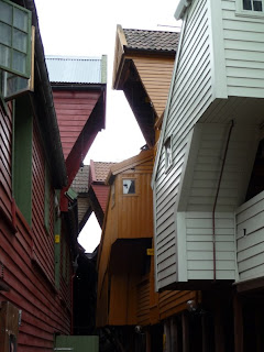
After a brief but costly stop at Dale's of Norway's sweater outlet shoppe in Dale, we drove on in to Bergen, Norway's second largest city, and lucked out with a parking spot just a block from the harbor, the Brygge and the Maria Kirke. We missed the English language walking tour, unfortunately, but decided we'd just do it ourselves. Pretty much everything of interest in Bergen is within walking distance of the harbor. Of particular interest were the Brygge houses, 18th century German merchant homes and business, mostly conserved and not restored. Some are pretty rickety, but all are in the gentrification process. It's another World Heritage Site. Bergen was a major Hanseatic League capital, and indeed capital of Norway briefly in the late middle ages, so there is all that (yawn) Hanseatic history. The harbor also features the fish market, which indeed had some fish, in addition to the usual tourist trinketry. The fishmongers were generous with free samples, and I managed to down a fair amount of salmon, cod, shrimp, and—a first for me—smoked whale. (Does not taste “fishy”). Also some more reindeer and moose sausage. All in all, the fish market was disappointing, more touristy than fish. We walked about the sentrum area, saw the Maria church (oldest building in Bergen), the most completely littered junk store I have ever seen, and then did some internet. It was cloudy and gray, threatening rain, so we decided to forego the highly recommended funicular for the view from up the hill. Somehow, Bergen did not send us. We proceeded on, after dinner, up the E39, across the Osterfjord, to Oppedal, on the Sognefjord, at a beautiful rest area, where we'll catch another ferry Tuesday morning. *would make a great name for an 80s Bergen rock group


Ground zero Bergen, especially the turbuss At the fish market, Norwegian caviar, not bad Smoked whale; about $30/lb; does not taste "fishy" Brygge, the old Hanseatic German quarter Vicki en route to the Christmas shoppe; the stairs eventually got her there Brygge back alley Ditto Maria church, oldest building in Bergen, they said, 13th century City Hall and square