...recounts the retirement travels of Mark and Vicki Sherouse since 2008...in Asia and the Pacific, New Zealand, Europe, South America, and Africa, as well as the US and Canada. Our website, with much practical information, is: https://sites.google.com/site/theroadgoeseveron/.Contact us at mark.sherouse@gmail.com or vsherouse@gmail.com.
Friday, February 6, 2009
To Invercargill
Beach at Blue Cliffs
We packed up and left Te Anau Wednesday. It has beeen our base of operations for all three major tramps on the lower part of the island, and we have gotten to know it fairly well, especially the downtown strip, the supermarket, Fiordlands Cinema, and the small but wonderful Te Anau public library.
From Te Anau we took the “Southern Scenic Route” south. It is the only road, but it is generally scenic, especially if you like hills, grass and sheep. En route we viewed Lake Manipouri, Te Anau's big neighbor, saw Tuatapere, from which the cruises to Doubtful Sound depart (next time!), and stopped briefly at Blue Cliff Beach, from which the brand new Hump Ridge Tramp departs into the more inaccessible regions of Fiordlands. The beach at Blue Cliffs featured views of distant Stewart Island as well as the largest beach pebbles I have ever seen.
We drove on, finally reaching the south coast, and camped at a crummy holiday park near Invercargill beach. At least it was cheap.
Kepler Tramp: High Road/Low Road
We divided forces for the Kepler Tramp. Vicki's knees needed a lighter work-out and definitely not the 3,000 foot ascent to the Kepler's Luxmore Hut. So, on Tuesday, she did the lower, level part of the tramp, from Rainbow Reach to the Moturau Hut, over-nighting there, and returning to Te Anau on Wednesday. This is the third or last day of the tramp.
At the same time, I did the first day of the tramp, to Luxmore Hut, and ultimately, to Luxmore Summit, and back. I took the Kepler water taxi across the lake to save 5km and then started up the unrelenting climb to the hut. I have never seen such a trail. Never very steep, but always up, even the bridges. It was the standard, groomed DOC Great Walk track, gutters on both sides, wide enough to walk two-abreast, stair-cased in the steep or washed-out areas, then board-walked across the more sensitive parts of the tussock. I arrived at the hut a mere 4 hours after departure, just in time to see the heli landing, and 30 minutes less than the “standard” DOC posts at every track. (These standards are set by Hamish MacHaste, NZ's 1000 meter record holder).
After check-in and a quick lunch at the hut, I decided to continue on to the Luxmore summit. It was a fine if blustery day, but clouds and drizzle were predicted for the afternoon and next day. So, after lightening my pack a bit at the hut, I proceeded on the next mile or two, another 400 meters up, to the summit. The last bit was rocky outcrop, but even there was a discernible DOC path right to the top. The crux of the route was simply not getting blown off. I lingered, took a number of pix, and reflected with satisfaction on the 4,000 feet I had climbed between 9AM and 3 PM. I don't think I have covered that much altitude in a day since the 1980s. There was energy left, so, after a brief rest at the hut, I walked out to the Luxmore Cave, a nascent, unimproved (no trail, no lighting, no signage) cave, a hundred meters long, on Mt. Luxmore.
The evening featured pleasant conversation with a Munich couple whose travels the last several months closely tracked our own. They were in Agra and Pushkar when we were, also in Bangkok, also on the Abel Tasman, etc.
I got up early the next morning, hiked down quickly, caught the 9:30 water taxi back to Te Anau, and met Vicki at the library.
A DOC Heli Lands at Luxmore Hut Just as I Arrive
Luxmore Summit from the Kepler Track
Summit View Toward Te Anau
Self-Portrait
Sunday, February 1, 2009
Remedial Routeburn
Mirror Lakes; Click to Englarge and Read the Clever DOC Sign in the Center
Christina Peak, from Key Summit
Another Peak in the Vicinity
Aotearoa: The Land of the Long White Cloud
Sunday morning I took the TrackNet bus up from Te Anau up to the Divide to fetch the Bongo. It was a fine day, some high clouds, so from the Divide I hiked up to Key Summit, an off-shoot of the Routeburn, to see some of the things we missed on the first rainy down out.
Routeburn Tramp; Or, There and Back Again Via Bus
The Routeburn Track, another of New Zealand's “Great Walks,” encompasses parts of two national parks, Fiordlands and Mt. Aspiring, and, like most mountainous regions, there are places you can't get to from here. Whether you do the Routeburn east to west or west to east, you are still faced with a 350km ride, normally via bus, back to your starting point. Having already done the last day's part of the Routeburn as a day hike earlier in the month, we had hoped to avoid the bus trip with a little back-tracking. Thus, we thought we would do the first day from the Divide to Mackenzie Hut, then cross the pass and stay at Routeburn Falls Hut; and then, having already done the rest of the tramp, back-track to Mackenzie and then back out to the Divide, where the Bongo was parked. No bus ride. Clever. Except that the second day, Lake Mackenzie to Routeburn Falls, across the pass, was much harder than we anticipated. The Routeburn is a “moderate” track (not “easy”), and the pass section, virtually the whole second day, was rough alpine trail, not the groomed DOC track to which we have grown accustomed. It was particularly rough on Vicki's knees, which don't like the rockier alpine paths, boulders, downed trees, stream crossings, and such. Add to this it rained most of the first day and all of the second, and we saw little of the advertised alpine scenery. By the time we reached the Falls Hut late Friday afternoon, we had resolved to continue on to the track's end, an easier downhill trail to Routeburn Shelter, and do the bus return, via Queenstown, to Te Anau; and later, just me, back to the Divide to pick up the Bongo. We did get to see a bit of the alpine stuff, peaks and glaciers and such, on the way out, the third day. And despite the white-outs and rain, we saw some interesting sights the second day, a helicopter landing in the white-out, tarns, waterfalls, alpine flora, and so. Tree-line, bush-line here, is only about 1000m. (I observe, FWIW, that there are many bushes above bush-line, but no trees). And we met and broke bread with more nice people, lots of Kiwis, two Americans, two Canadians, a Finn and an Ozzie. The Ozzie explained the Oz thing about Australia to me. The beech forests were rather better on the Mt. Aspiring side, we thought, which we had already seen (Lothlorien), and it was noticeably drier there. Several streams and one big waterfall were already gone since our last walk, two weeks before. There also were no sand-flies on the east side. The Canadian couple, very experienced younger trekkers who were coming off both the Greenstone and Routeburn tramps, agreed that Alaskan mosquitoes were far preferable to Kiwi sand- flies. You can at least see the Alaskan bugs and occasionally bring one down. The highlight of the tramp, at least for me, was the very entertaining hut warden at Mackenzie, who gave us useful information about the granite worms and also about predicting local weather. “If you can see Mt. Dunston out that window, it will soon rain; if you can not see Mt. Dunston out that window, it is raining.” The bus rides from Routeburn Shelter to Te Anau afforded opportunities to briefly revisit Glenorchy, Lake Wakatipu, Queenstown (a lay-over), and Mossburn (the deer capital of New Zealand). Just north of Mossburn we were treated to a double rainbow. I had seen a triple rainbow before—in Missoula, of course—but the double was still unusual enough to be of interest. The bus and other tourist transportation in these parts, and throughout NZ, is excellent. Mostly it is private, but very affordable, and goes just about everywhere. In Fiordlands we have ridden TrackNet several times, all around Milford, Te Anau, and Queenstown. We met one Ozzie family that got off the four-day Milford Tramp at 2 PM, immediately caught the boat to Milford Sound, the 2:30 TrackNet bus back to Te Anau and then Queenstown airport for their flight back to Sydney that evening. They were perfectly confident of the connections, said they'd done this sort of thing many times. With enough time, one could really do most all of NZ without a car.
Hollyford Camp
Gunn's Camp (aka Hollyford) is 7km off the road from Te Anau to Milford Sound. There's a general store, a museum (!), a number of interesting cabins for hire, an H-bomb, probably the oldest working petrol pump in NZ, and lots of signage. I love eccentrics. From a safe distance. We camped, as it were, at the Divide.
Milford Again
On the Milford Road
Peak and Glacier
A Grand Canyon, or More Like Yosemite
The Homer Tunnel, a Kilometer Long, One Lane, Just Big Enough for Tour Buses
Since we were embarking on the Routeburn Tramp from the Divide, we thought we'd just drive on another 50km and see Milford Sound again and all the fine scenery at leisure.
January 27, 2009—Te Anau
I did it! I did not have to be rescued by helicopter. I tramped (the correct Kiwi word) the four days of the “finest walk in the world,” the Milford Trek. Considering the last 3 days were 10 miles, 10 miles with 1700 ft of ascent and 3400 ft of descent, and then 12 miles—I am quite proud. Certainly the hardest 3 days I have done in a very long time. In Montana our limit for hiking was about 8 miles a day—we don't like to rush. Well, basically I can't be rushed—my knees just won't take rush. However, the first rest day I could hardly walk—much better now on day 3 off the tramp. It was worth it—it is a very well maintained trail, much better that ones in the Rocky Mountains. But I would only rate it as one of the finest walks in the world—not the finest.
Yesterday we had a nice half day kayak trip out into Milford Sound—which is not a sound at all, but a misnamed fiord. Again quite nice but not not as good as the build up. Milford Sound is the holy of holies in New Zealand tourism. Certainly worth doing—but I think the cruise to the end of the sound might have been better in this case. Kayaks are fun, but you can't go very far.
We start the Routeburn Trek on the 29th. It is a 3 day but we decided to backtrack and make it a four day and come out where we started. Otherwise we have to spend about $150 and 8 hours to ride 3 different buses back around to this side. We also already did most of the very last day on our day hike out of Glenorchy a week or so ago. That will only give us one rest day before we do a short two-day walk of the first part of the Kepler. But since the Routeburn is easier than the Milford, and I assume I am getting stronger, I hope that 1 day's rest will be enough.
Well, I need to go check the dryer and spend some time on the Internet at the library trying to figure out what we are doing in our 3 weeks in Hawaii other than our hike on the Kauai coast.
Tuesday, January 27, 2009
Kayaking on Milford Sound
Sunday it rained heavily all day at Milford Sound. We sat around at the lodge, visiting with tramp acquaintances, reading, watching waterfalls form on the cliffs above, watching those old rain drops fall. Even the internet was out of service. We had thought about taking a the shuttle into “town” to dine at the Blue Duck, the lone eating establishment in Milford Sound (there is also a motel and a defunct gas station—that's it), but opted eventually for another camper meal cooked in the lodge kitchen: Indian butter chicken, basmati rice, and a great Ozzie ginger beer, Bundaburg.
Monday dawned bright, cool, and sunny, with a few low clouds over the fiord. Vicki had scheduled us for a 7:15 AM kayak trip, so we rose quite early, packed up, ate, and shuttled down to the Sound to don our cold-water kayaking costumes (provided by the vendor, Roscoe's of Milford Sound). The change of clothing took place in a large tent (women) and outside (men), both exposed to the ravages of the worst sand fly attacks we have yet seen. The way we tramp and dress, only our hands, faces, and necks are exposed, and these are marinated daily in 100% DEET. (Viet Nam War surplus from CampMor, purchased in about 1976, I think. The stuff is powerful and goes a long way. It has removed the paint from my aluminum ice axe and other implements; but the the mosquitoes and sand flies evidently don't like it.) It is amazing how quickly one can change pants and shirts when one really needs to.
The morning kayak trip was most enjoyable, just the right length, little exertion, great vistas, no wind, and the fiord as placid as a calm lake. The only ripples were those of the passing cruise boats. (More pix when those from the disposable marine camera are developed and digitized). After another quick change and lunch at the Blue Duck, we caught the 2:30 bus to Te Anau. Normally, bus rides aren't all that great, but this one took us through Homer Tunnel and then through glacial canyons larger than any I've ever seen. The only thing NZ lacks, scenically, we have observed, is the Grand Canyon, and here we were, mile after mile, in what the Grand Canyon would look like if it were covered in rain forest and surmounted by peaks and glaciers. We're vowed to drive back to Milford Sound to see it all again, just before embarking on the Routeburn Tramp Thursday morning.
Waterfalls Forming in the Rain at Milford Sound
Milford Sound
Mitre Peak
Keas Again
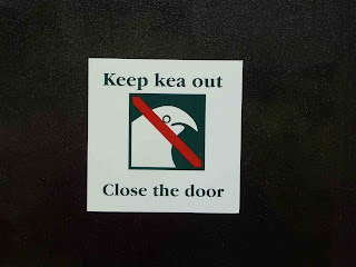
Keas are the alpine parrot found on the South Island, mostly in Fiordland National Park. They are about the size of a chicken and are not flightless like some other notable Kiwi birds. Until our Milford Tramp, we had not seen one, but had heard and read plenty about them. On the Milford, we saw and heard plenty of kea, especially at Milford Sound. They are very curious, not very fearful, and will take anything not nailed down. All of the hut wardens on the Milford cautioned us to leave nothing outside the hut on the porch. The kea are particularly fond of hiking boots. One warning we saw told us that (paraphrasing) “keas typically operate in pairs; one distracting you with its clownish antics while the other goes after your wallet, your keys, camera, sunglasses....” I saw one pecking the insulation out from a car's windshield. They start calling one another at about 4 in the AM, more of a loud, prolonged, plaintive high-pitched “meow” than a “kea.” But it can't be pining for the fiords.
Reflections on the Milford
The Arthur River
Sunderland Falls
Dumpling Hut
Sandfly Point, End of Tramp
I need to read up on some geology, geography and climatology. The mountains here are not very high. The highest, by far, is Mt. Cook, 12,000 feet, inland and far to the north. Yet there are all these enormous glaciers and evidence of even greater glaciers in the past. On Lake Te Anau we passed over the 45th parallel. Here in NZ, we are not nearly so far south as Missoula, MT (no glaciers), is north. And Missoula is far higher than anything here but the highest peaks. (The 45th, BTW, passes through only 3 nations: Chile, Argentina, and NZ). There is a super-abundance of moisture here and consequent rain forest. But why the ice? Not altitude, and not latitude, at least by my lights.
We were pleased to have done the Milford. Among trekkers, it has got to be on everyone's list of treks to do. For me, there was a certain monotony—same canyon features, same beech rain forest, same falls, a mildly interesting pass, and then back into the trench, more canyon features, forest and falls. Sunderland was a treat. Milford Sound, the fiord, is very scenic, by any standard, but it's not part of the tramp and one can drive one's car to see it. DOC facilities, staff, and track were, as in the past, superb. Other trails are "maintained"; DOC tracks are positively groomed.
The sand flies did live up to their billing. According to Maori legend, one of the hut wardens said, it was the Goddess of Darkness who gave us sand flies, to remind us to keep moving. Perhaps the most important thing we learned on this tramp, other than to keep moving (we already knew that!), is that the flies don't bite at night. They really don't. A gift of the Goddess of Darkness.
Milford Tramp
The Milford Tramp is billed as “the finest walk in the world.” It is certainly the most highly-regulated. Camping is not permitted. Only 40 trampers are allowed per day, and they must stay in the three huts, the Clinton Hut, the Mintaro Hut, and the Dumpling Hut, in order. Travel is one way only, south to north across Mackinnon Pass. The start is at the top end of Lake Te Anau, which you get to via boat, and the end is at Sandfly Point, from which you catch another boat to Milford Sound, on the fiord. Unless you have made other arrangements, there are also two bus rides involved, from Te Anau to the lake boat at Te Anau Downs (30 minutes) and from Milford Sound back to Te Anau (two hours). There is also a guided walk program, nicer accommodations, food, transportation, provided, etc., for a smaller number of “trampers,” at about 800US$ per person. The guided walkers we saw were mostly Japanese.
The tramp takes you up Clinton valley, 16 miles, to Mackinnon Pass, then down Arthur Valley, 17 miles, to Sandfly Point. Except for the upper reaches of the pass, you are in an ancient beech forest all the way, low ferns and other plants, too. The two valleys—canyons, really—are deep glacial trenches with high walls on either side and at their heads. Above the 2,000-3,000 foot walls are the largely unseen mountains with their snowfields and glaciers. If you like waterfalls, this is the hike for you. There are hundreds, thousands, all different, most enormous, culminating in the 1,900 foot Sutherland Falls, one of the world's highest. Although rain was forecast for our tramp, all four days, we saw only a bit of drizzle two afternoons and actual rain only the third evening. But even a little additional moisture here creates new waterfalls, and part of the interest is seeing a “new” waterfall appear where there was none only a moment before. With all this water and the constant cleansing and washing of everything, the creeks, and then the rivers, the Clinton and the Arthur, are the clearest flowing bodies of water we have ever seen, deep and wide and powerful, too.
On the Milford, you're with the same group of 40 for the entire tramp. Our group was about half Kiwi—several families tramping together—a Canadian, Michel, the 3 amigos from Colorado, a couple from Alaska, us from Montana, couples from Poland, Israel, and others from Germany, Denmark, and elsewhere. Vicki and I were the oldest and slowest, but then we generally are. People bond, more or less, on these tramps, and we had a good group with whom to bond, especially our fellow Americanskis. Interestingly, all of us are spending considerable time in New Zealand and loving every minute of it.
The crux of the tramp, for many, is the third day, with its ascent of Mackinnon Pass, about 2,000 feet up and more down. We reached it without much exertion. The pass itself was a hurricane, as most passes are. We had a hiker's lunch at the pass hut, the fifth hut on the premises: the previous four had blown away. The walk down was not as bad as expected. DOC has installed a number of wooden staircases at the steepest and washed-away points. And before arriving at the Mintaro hut, one can enjoy the side trip to the base of 580 meter Sutherland Falls.
The crux of the tramp for us was the fourth and final day, 12 miles from the hut to the boat. Our tickets were for the 3:15 boat, the last of the day, we were given to understand. The night before, heavy rains were predicted, up to 200mm (6-8 inches), and we were told not to begin the hike before the 7 AM weather report. The track often floods out, the hut warden said, and in such circumstances, it was not unusual for hut occupants to be flown out by DOC helicopters. So we went to bed hoping for a helicopter rescue! There was no rain that night, nor the next day (it all passed south), and so we departed the hut at 7:05, trudging the last 12 miles to Sandfly Point. The last day is largely level ground, scenic nonetheless, and we were greatly relieved to arrive at the Point early, at 2:45. The boat captain informed us that, oh yes, there is a 4:00 boat, and later boats, until everyone is accounted for. No one has ever been left over-night at the aptly-named Sandfly Point. Vicki vowed to protest to the DOC. But as we rounded the Point, the fiord came into view, with Mitre Peak, other mountains, glaciers, and more waterfalls, and the anticipated grand view was both reward and relief.
Vicki's boots being baptized (to prevent the spread of the didymo ("rock snot") organism |
Standard Milford view |
At Mackinnon Pass |
A glacier above the valley |
Monday, January 19, 2009
Mavora Lakes and Mararoa River
"Two hobbits lay here...thrashing about...
what were they doing?"
|
Hiding from Uruk-hai |
The Log Under Which Merry and Pip Hid from the Uruk-hai |
The Ranger Who Gave Us Directions |
The major LOTR sites of the day were at the Mavora Lakes and Mararoa River, 40km from Mossburn, itself pretty well removed from anything except sheep ranches. (We have concluded that a “burn,” as in “Mossburn” or “Routeburn,” is a creek or river). Around the lakes and the river were perhaps the richest collection of LOTR sites we have yet seen. The sites all had to do with the dissolution of the Fellowship, the departure from Lothlorien, the Uruk-hai attack on the band, the capture of Merry and Pippin, and Frodo and Sam's escape. Also nearby were the site of the Riders of Rohan attack on the Uruk-hai, where they burned the corpses, where Viggo Mortensen broke his toe, where Merry and Pippin escaped into Fangorn Forest, and the Forest itself.
Not a bad day's Ringer work, aided, as always, by Ian Brodie's guidebook of LOTR sites. Brodie's book is indispensable, if exasperating at times. A typical description would go like this. “The site is located on a farm road between Auckland and Queenstown. Please shut the gate after entering. Drive another 10-50km, then turn onto a paddock bordered by trees. The site will be immediately recognizable. Behind the bush is where Elijah Wood lost his third set of hobbit feet.” We found the stump (actually a log) under which Merry and Pippin hid in the forest from the Uruk-hai only through the kindness of some nearby campers. A ranger's directions had proven unfruitful—he seemed not to have high regard for Ringers—although his advice did afford us a nice mid-day hike around part of the north lake.
In fairness, I should add that Brodie provides GPS coordinates for all the sites, and such coordinates and the ability to find them would be nearly as indispensable at the book itself. Months ago we decided not to invest in GPS technology for our Asia/Pacific trip. It would have been useless in Asia and one more heavy valuable to lug around and guard. There have been days here in NZ when we wish we had done otherwise. But by and large it's been feasible and perhaps even more fun “the old fashioned way.”
Queenstown to Te Anau
Monday's drive from Queenstown to Te Anau—200 or so km—took us from one huge mountain lake to another, further west and south, but across ever changing ground. The departing views of Queenstown, across the lake, were great. After an hour or so along the west side of the lake, including Kingston and its working steam engine, the land became very dry and open, similar to the American West. Many scenes could have been Montana's high plains, ringed by mountains, but dry and rolling, the sage brush replaced by some low-growing, drought-loving Gondwanalandian shrub. A 40km detour over unsealed road (but no ford) took us to the Mavora Lakes, two beautiful trout-laden high lakes back in mountainous country. The last leg saw us in more rolling agricultural country, approaching Te Anau, the largest of these huge lakes, and the mountains of Fiordland.
Agricultural country. Indeed: all of New Zealand. Everything grows here, everything thrives here, on one island or the other and in the seas about. We ate at a restaurant Sunday night in Queenstown whose menu noted that all its dishes and ingredients were locally produced.
Queenstown from the Other Side of the Lake
The Kingston Flyer
A Real Kiwi Campervan
“They have such beautiful eyes,” (to paraphrase a Gene Wilder line from a favorite Woody Allen flick). According to tourist publications on driving in the back country, one should drive right straight into a flock like this at 5-10kmph and not hesitate nor waiver; the sheep will make way. If you stop, they will stop. That's exactly how it works, too.
January 19, 2009--Queenstown
We are just packing up to head to the Morevia Lakes and Te Anua region. There we will visit Fanghorn Forest ,another Ring site, but also begin the Milford Sound Trek which National Geographic proclaimed as the Best Hike in the World. Ever since the 80s it has been highly regulated. (We booked on July 15) Only 40 people can begin the 4 day hike each day. There is no camping allowed, everyone must stay in the huts and everyone hikes it in the same direction. The first day will only be about 2 hrs of walking as you have to take a 30 min bus ride from Te Anua to the start, then a boat to the actual start. I am most worried about days 3 and 4. Day 3 is 10 miles with a 1500 ft elevation gain and a 3000 ft descent over the pass. That is a lot for my knees even with the braces on. I have not done that much on this trip while carrying a pack. The 4th and last day is long for me at 12 miles but after day 3 I'm sure my legs will be talking to me. Unfortunately, the last boat that takes you to the lodge at the end of the road leaves at 3:15. There is no trail, so if we miss it, we spend the night without a tent at a wonderful place called Sandfly Point. We have been getting ready--and I think I can do it--I just hate having a deadline to worry about. We will spend two nights at Milford Sound at the backpackers lodge and kayak part of the sound after a rest day. Then we catch a bus back the 60 miles to Te Anua. One nice thing is that we can send a pack ahead on the bus to the lodge so that we can have a change of clothes and other amenities that we wouldn't be able to carry in on our backs. Mark and I have learned to backpack very light. It is great for the diet. If you have no food, you can't get fat!
I think Mark is doing a pretty good job in describing everything. Of course, he doesn't have the proper respect for the Ring sites we are visiting. But in reality he is really enjoying them as he is a big fan of the movies. Trying to find some of them has been difficult as we don't have a GPS and some of Brodie's directions are none too clear. Also some things have changed in the 8 years since the movies were made and 5 years since the location book was written. The hunt has taken us to many places we would have missed otherwise. It has reminded us of our trip to Europe in 1989. When we were in England and France we did a lot of hunting for menhirs and other paleolithic sites for Mark and then many fairytale and children's sites for the girls based on a book called Heidi's Alp. It really adds another dimension to a trip when you can drink from the spring that Heidi did (unfortunately, so did her sheep.)
Riders of Rotel
Vicki and I became acquainted with Rotel on our first trip to Europe, in 1979. It is a touring arrangement consisting of a bus and huge tractor-trailer. Passengers ride by day in the bus, stay in campgrounds, cook their own meals, and then sleep in little compartments in the trailer (“coffins” Rebecca and Rachel called them back in 1989; I think Vicki had told them Rotel was a traveling vampire troop). See illustration. I'd guess they can carry 50 or more people. We have seen them, over the years, in London, Paris, Rome, Venice, Yosemite, the Grand Canyon, Denali, and other such places. Fiordlands National Park, where we are just now, camping at Lake Te Anau, is such a world-class place—one of the four adjoining national parks that comprise NZ's great Southwest World Heritage Site—and it is strangely reaffirming to see Rotel here too. We'll be camping in Te Anau Monday and Tuesday, do the Milford Tramp Wednesday-Saturday, staying in DOC huts, and then will spend Saturday and Sunday nights at the lodge in Milford Sound. Monday we'll do some sea-kayaking in the Sound before returning to Te Anau and resting up for the Routeburn Tramp, two days later. Milford Sound has internet, but we probably won't post any blog pix for a week or so. Periods of rain are forecast on the Milford Tramp Wednesday through Friday, but that is par for the course here. In Hawaii, they say “no rain, no rainbow.” Here it would be “no rain, no rain forest, nor glacier, nor fiord.” Nor sandflies.
Subscribe to:
Posts (Atom)