Sunday, November 8, 2015

Canyonlands' Island In The Sky, 2

We awoke at Willow Flats CG to a dusting of snow and temperatures in the lower 30s. But the day's forecast promised sunshine and temps in the 40s, good walking weather (good, not optimum), and so we headed off to more sights and short hikes in Canyonlands' Island in the Sky unit.
Thus


And thus


And now we are walking along the rim at Grand View Point
Overlook, 6,000 feet, a mile walk out to the Point for more
views of the Green River canyons


A different part of the White Rim


With its own needles and such


Marching along, enjoying great light


More sights


Our little hike done, we are now over on the other side of this
arm of the mesa, looking out to the Colorado River basin


Part of the Buck Canyon overlook


Thus


And thus


And now we are on the short walk to Mesa Arch, one of
Canyonlands' many arches


Closer up


The view


Mesa Arch flies right over the cliff...no pix from the other side!


Saturday, November 7, 2015

Canyonlands' Island In The Sky, 1

Omnia Gallia in tres partes divisa est. Caesar would have said the same of Canyonlands National Park, identifying its three units as the aptly named Island in the Sky, the Needles, and the Maze. There are three distinct units of the Park because the place is so remote and inaccessible that you can't really get from one to another. There are 4WD roads here and there, and that is how most travel occurs in this place. We spent a couple days sightseeing in Island in the Sky--atop a huge mesa jutting into the Park--the one unit fairly accessible to normal autos and RVs. Oh yes, there is actually a fourth unit of the Park, Horseshoe Canyon, which Caesar didn't know about, and that's where we really got our feet on the ground. I'll post on it in a few days.
From the Green River overlook; yes, that Green River, which
we more often associate with Wyoming and the Wind River
Range


It's out there in the distance, a thousand feet below the White
Rim, which is a thousand or so feet below Island in the Sky
and its overlook; the Green and the Colorado  finally merge
a bit south of here, deep in Canyonlands


Panning around


Thus


Ditto


At Upheaval Dome, now thought to be a meteorite crater; it's
in the mid-40s, I am shivering, and a storm is moving in; and
"Heat Kills"


Need to find higher ground as one of these approaches


From The Neck, Shafer Canyon the other side


Shafer Canyon


Street scene


At length, we camped at the Willow Flat campground, near the
Green River Overlook; note covered picnic table


Tuesday, November 3, 2015

La Sal Loop

The Manti-La Sal Loop takes you from the Colorado River, east of Moab, through canyonland country and up into the snow-crested La Sal Mountains, a spur of the Colorado Rockies; then back down again to Spanish Valley and Moab. The altitude gain is about 4,000 feet, but the variety of terrain you can see in an hour is pretty neat.


Fisher Towers

Exactly 21 miles up the Colorado River from Moab is the short road to Fisher Towers, a place of spectacular southwestern scenery and also a hub of rock-climbing activity. We hiked the Towers back to The Titan and then drove the Lasal Loop, up into the mountains and then back down to Moab, all on Monday.
Environs, Fisher Valley


Some of the Towers, from the trailhead


Proceeding on


Way up there


At least two parties on this one


Way up there


Posing


Lunch break, with cup-holder


The Titan, the big one we came to see...900 feet above the
valley


Fixed ladder on the trail


Towers all over


And a last look

Arches National Park, V: Fiery Furnace

The Fiery Furnace is one of those clumps of fins, those long up-right rock features that sometimes erode away to become arches. Arches National Park has several such clumps, obviously, the most famous of which is the so-called Fiery Furnace. So-called because of its fiery appearance in certain sunsets, not because of any thermal properties. Anyhow, I signed up for a ranger-led hike in the Fiery Furnace Saturday. Vicki demurred since the hike involved a variety of scrambling moves that might well have over-taxed her artificial knee. I found the hike challenging, not because of any of the moves required, but because of my vestibular disability. But I did it, and I don't think anyone noticed I was doing it on a rocking and rolling vessel.
Google Earth view of the Fiery Furnace, 3 miles up; how do
those little cars get so high?


Ranger Glenn explains fins and arches, and salt domes, using
a sponge model; I've been going on NPS ranger hikes since
1970; scores of them, many scores; this was one of the best


A pot-hole arch, small


Another, larger


Another, small; in order to qualify, according to the NPS, a
span has to be at least 3 feet, admit light, and be natural


Looking up, occasionally


But mostly down, to see where you're going


Ranger-led hikes typically take you places you cannot or should
not go by yourself; and there's generally far more talk than
walk--in 3 and 1/2 hours we walked maybe a mile and 1/2--but
the talk is the great thing, something you'd not get any other
way


Nice double arch; alas, I don't recall many of the arches' names


A pot hole; it rained a few days back; but swimming in this
pot hole and others are tiny Fairy Shrimp; one of those
organisms that seems to survive almost anything; speaking
of which, check out Tardigrades...inter-galactic travelers?


Again, looking up


Executing the "slide on your butt" maneuver; we'd already done
some chimneying


Another medium-sized arch, the Kissing Turtles


Many readers have asked why I don't post more pictures of
coyote scat; OK, so here is some coyote scat
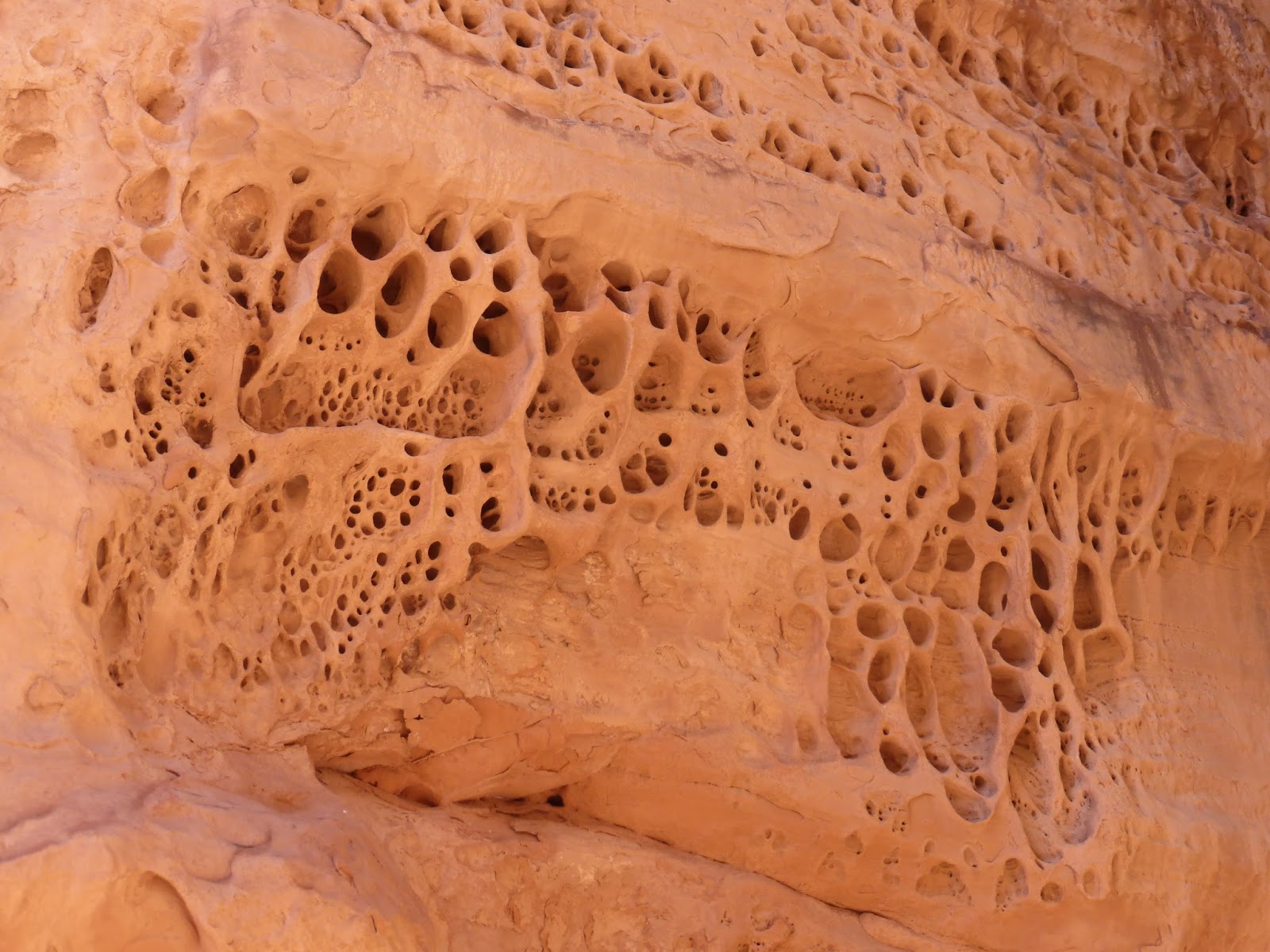


Erosion


More arches


Fin-land


One final arch, the best of them


Thus


Great place, great hike