Monday, September 21, 2009

Ring of Brodgar, Stones of Stenness, Maeshowe

Below, a few more of the Orkneys' major complex of neolithic stuff. There is far more spread all around the islands.

Vicki at the Ring of Brodgar; it's the 3rd
largest stone circle, 140m in diameter;
about 40 of the original 60-some stones
still standing


It's really too big to get in one photo


Several of the stones are split; several have
been downed by lightning, as recently as
1980


Me by one of the bigger stones


Half a mile away, the Stones of Stenness, another major site


And a big stone foresight right in somebody's yard

Another mile or so away is Maeshowe, usually billed as
Europe's finest passage monument...but we thought it was
not in the same league with Gavrinis, Newgrange, Knowth;
or maybe I am still bitter about not being able to take
interior pix; Norse-types broke into the "tomb" in the
12th century or so, partied for 3 days (so it says in the
Orkneysaga), and left all kinds of "interesting" runic
graffiti ("Jarvold carved these runes," "Erik bedded Helga,"
"Sonhenes carves the best runes," etc. 


Skara Brae

In the 1850s, a huge North Atlantic storm blew away several feet of beach and 
upland on the west coast of Orkney's main island and revealed the best instance 
there is of a preserved neolithic village, now reckoned to be some 6,000 years 
old. It has been excavated, analyzed, written about, and exhibited. There is a 
fine museum/visitor center and a "replica" of the most famous room to enter 
and touch things, ground level. If you're into prehistory, it's one of those things 
you have always read about....  Above, an overview; the roofs (presumably 
thatched) are gone now but reveal floorplans, hearth, stone furniture, 
implements, etc.


Classic living area, note stone beds, stone storage/display area


Somewhat different floor plan

All the rooms connected to the larger work/commons area

Grain grinding apparatus; Skara Brae was inhabited for about 600 years, then 
abandoned

Around "Mainland" Orkney

Stromness, the Orkneys' second largest city...doesn't sound Scottish does it?


Sea cliffs on the west side of the "Big Island"


Hoy is the large island south/southwest of the "mainland," and on its west coast is 
famous sea stack, The Old Manof Hoy, something I've always wanted to see...
here it is,perhaps 15 miles away; there are something like sixty islands in the 
Orkneys, but fewer than half are inhabited

Surfing at Skara Brae


Italian Chapel

Italian prisoners of war (from the first Battle of Tobruk, in North Africa, 1941) constituted the labor for building the Churchill Barriers; among other things they built was the Italian Chapel, two quonset huts joined together, now a tourist destination. It really is a trompe l'oiel masterpiece, given the circumstances. There were Italian POWs at Fort Missoula during WWII, similarly talented, who made contributions there as well, and about whom there are books and even a documentary film. Italy came over to the Allied side in 1943, and after that, these men were no longer POWs; the Brits kept them in Orkney, nonetheless, but paid them for their work. After the war, several took their Orcadian wives and children back to Italy. Of the Orkneys, however, none apparently said, as they did of Missoula, "Ah, POW camp in Missoula, the best three years of my life!"
Italian Chapel


Altar


Stations of the Cross
Ribbed vaulting


Behind the false front


St. George...concrete over barbed-wire


War-time Orkney

We awoke the 13th to milder wind and mist, drove in to John O'Groats, looked at the forecast, and decided to go for it. The boat ride—45 minutes—was fine, with increasingly better weather as we got to the islands, and then better entirely as the day progressed. We debarked at the southernmost island and port, whose names escape me, then boarded the turbuss and proceeded on, first through the ChurchillBarriers, then to the Italian Chapel, then to St. Margaret's, then to Kirkwall, then to Stromness for lunch, a dreary wet gray place, then to a western cliff overlook from we could the Old Man of Hoy, then to Skara Brae, then to Ring of Brogdar, then back Kirkwall. At Kirkwall we debarked and, having carefully checked arrangments with the driver, walked to the B&B, the Lerona, on Cromwell Crescent. The place was fine, the hostess hilariously Scottish, the yard decorated with ceramic gnomes and ducks and the rest. We had a very decent dinner at the Kirkwall Hotel, roast beast for Vicki, scallops—very fresh—for me, plus the mixed seafood appetizer.
Yes, we were on a turbuss


After the incident with the U-boat, the Royal Navy erected huge concrete 
barriers connecting four of the islands and blocking eastern access to Scapa 
Flow, their war-time fleet anchorage; they are now called the "Churchill 
Barriers"; most interestingly, they cause the tides to hit the eastern side of 
the islands two hours later than Scapa Flow, with a  differential as high as 
four meters, which we witnessed
The buoy marks the Royal Oak site, now a national cemetery--800 men died


A bit further down the Flow is where the German High Seas Fleet scuttled itself, 
74 ships, during armistice negotiations in 1919; they were probably getting tired of 
haggis, neeps and taddies; it is now a scuba-diving paradise; bring wet suits


Duncansby Head

We drove on the few miles through Wick, then  on to John O' Groats, the traditional Land's End of Scotland (but not really; that's Dunnet Head, a few miles west; and north), which is basically the ferry landing plus a few wind-blown tourist shops, hotel and B&B, tourist office, campground, and car park. We made inquiries at the ferry office and resolved to stretch their “maxi-day” tour of the Orkneys into two, so we could see Maeshowe, the Highland Park distillery, and a few other things. We'll stay overnight at a B&B in Kirkwall. And the Grey Wanderer will stay here in John O' Groats while we are in the Orkneys. After lunch, we drove out to the lighthouse at Duncansby Head, and pretty much stayed in the Grey Wanderer the rest of the day, weathering a hurricane on the cliff overlooking Pentland Firth and its tremendous storms and tidal flows. It's where the Atlantic meets the North Sea. But all you can see today is gray—the sea a slightly darker gray than the sky. Nothing of the skerries and islands just a few miles away and just a bit of the famous sea stacks further down the head. We'll spend the night at a lay-by on the sea just west of John O' Groats, Gill's Bay.

Why the Orkneys, you ask? Well, one reason is the megalitihic stuff. Along with Wiltshire, the River Boyne, and the Gulf of Morbihan, the Orkneys are one of the four or five great neolithic complexes of Europe. We've seen most all of the others, but not this one. We've been reading about it for thirty years. Second, for me, the Orkneys are an historic WWII site, Scapa Flow the great British fleet anchorage into which Gunther Prien's U-47 sailed, on the surface, in October, 1939, and sank the battleship Royal Oak. After the armistice, in 1918, it is also the place where the German High Seas Fleet scuttled itself, 74 capital ships to the bottom, in 1919. And, lastly, but most vitally, the Orkneys are home to that greatest of all spirits, my long-time favorite, Highland Park single malt whisky.

And, finally, you ask, who was John O' Groats? A martyred saint from the Western Isles? A fierce Viking raider or explorer? Another traitorous Jacobite sympathizer? What is a groat, anyway?

Answer: none of the above. James IV commissioned Jan de Groot and his brothers to operate a ferry service to the Orkney Islands from here in 1496. Scotland had acquired the Orkneys from Norway via royal marriage in 1468. Bonnie Jan O' Groots!
Fixer-upper castle near Wick; waterfront view


The Duncansby sea stacks, impressive even in a hurricane


A few days later, after our return from the Orkneys


Duncansby Head from the Pentland Firth, fair weather...


John O'Groats Ferry Service, family-owned
and operated since 1496 (well, maybe not the
same family)


Bluff, New Zealand, 12,875 miles; sort of ties
things together...


Hill O' Many Stanes

The Hill O' Many Stanes is another neolithic construction, 4000 years old or so, an alignment of some 200 stones, none very large, into 22 rows proceeding down the hill. Research has shown that at one time there were more than 600 such stones and that, as the alignment proceeded downhill, it fanned out slightly. Alexander Thom, a 20th century astronomer/archaeologist/professor of civil enginnering, suggested that Hill O' Many Stanes was a lunar observatory, that is, an observatory for following and mapping moon positions and period. (The lunar cycle (transfer) repeats every 18.61 years, right?) (Stonehenge, both a lunar and solar observatory, some say, is where they finally got this right.) Anyhow, whether it was all for religious, civic, agricultural, “scientific” or other reasons is anyone's guess. I have read that there are other similar alignments in Britain, mostly quite degraded, and probably more still buried beneath the sand or gorse or heather or peat. Of course, none approaches the size nor extent of Carnac's great alignments. But they're all about equal in inscrutability, I think.

That's how they say it 


One perspective


Another


By daylight


Thane of Cawdor

September 11 We drove on, just 10 miles or so, to Cawdor and the Castle there. We had seen it in 1989 with our daughters and enjoyed it very much. The 6th earl, now deceased, had a wonderful sense of humor, and himself wrote the narratives describing each room, its history and artifacts. Many of the descriptions, including of ancestors, are hilarious, as are some of the art itself. And the “Thane of Cawdor” connection with Macbeth is played just right...a bit of fun, no more. After walking the woods, maze, and gardens, we drove back through Inverness and then headed north along the A9, across the Firth of Moray and then still further north along the coast.

North of Inverness, the scenery grows sparser and sparser, treeless Highlands on the left, grassy hills and then cliffs falling to the grey North Sea on the right. Another firth contains four massive oil rigs and in the bay and sea beyond there are more. We pass the Castle Dunrobin, set right on the sea, shining in late afternoon sunlight, the stronghold of the evil Sutherlands, arch-enemies of the Mackays. Vicki hisses while I snap a few pix. It is another beautiful fortified residence, perhaps the most interesting I have seen, at least from without. And then we drive still further north, up and down hills, past small villages by the sea, then over round summits overlooking them, until we come to Lybster and the Hill O' Many Stanes, in a farmer's field only a quarter mile off the highway. There is no car park—only a wide spot in the country lane—but we resolve to park and stay at a level entrance to the field. It is getting late.

Cawdor Castle


Cawdor crest, "Be Mindful"


"Double bubble, toil and trouble, cauldron
burn and fire bubble," I always say, watching
the microwave; this is the only reference in
the house to that Macbeth


In the maze garden


In the flower garden


I think I remember this sequoia from '89


Oil rigs in the firth


Castle Dunrobin


Thursday, September 17, 2009

Isle of Skye interim report

We are on the Isle of Skye, in the Hebrides, off Scotland, heading next via ferry to Lewis/Harris Islands, to examine the Harris Tweed and the Stones of Callanish, posting presently from the high school library. We'll post more--a week or more now to account for!--when we get back to wifi-land.

Friday, September 11, 2009

Clava Cairns

Next (jumping back a few thousand years), we drove on another mile and a half to the Clava Cairns, a wonderful collection of three different neolithic tumuli, one an open passage grave, one an enclosed and once corbel-roofed passage grave (as in Ireland), and the middle one, something I have not seen, a chambered area, open, but with no entrance nor exit...a ring cairn. All are ten feet high or so and 75-100 feet in diameter, and are oriented to the SW and the winter solstice sunset. Most interestingly, they all size the kurb and other stones, smaller toward the sunset and larger back from it. And, the kurb and outer circle stones are color-coordinated. See illustration. The outer circle of the SW tumulus also has double-stones—one very large, others smaller. Again, something new to me.

Quite a few of the kurbstones have cup marks, suggesting more recycling from previous aeons. Cup marks are both paleolithic and neolithic, found all over Europe. This was thousands of years before metallurgy, especially in these parts, so it was stone on stone, day after day, to cut one of these little figures into, typically, granite or schist. Every one of them must have meant a great deal to whomever was chipping away at them. And we have not the merest clue as to what they or their cup-and-ring figure relations might have meant. “Sublime” generally refers to gigantic natural features...mountains, glaciers, desert wastes...but I am always in awe of these human vestiges. Somehow, they put things in a different perspective, in a different dimension.

Or, as Vicki observes, hey, no internet, no DVDs, no television, nothing to read: what are you going to do?

We camped at the Clava Cairns car park, way off the main roads, near the Firth of Moray, deep in farm country.

Lest anyone be concerned, we're eating well. Dinner tonight was Scottish breakfast, eggs, tomatoes, mushroom, toast, beef lorne, fruit pudding, black (blood) pudding, and beef links, washed down by Dark Island, the best dark brew I have yet had (from the Orkneys, “5,000 years in the making”). Cholesterama.
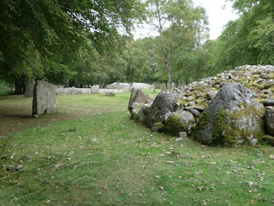
All three of the Clava Cairns


The northeastern-most cairn, used to have a corballed roof,
like in Ireland


Middle cairn, the ring cairn


No exit; no entrance


Double-stones on the outer circle of the
southwestern-most cairn


Color-coded stones


Cup-mark city

Dinner