Wednesday, February 26, 2014

North By Northwest

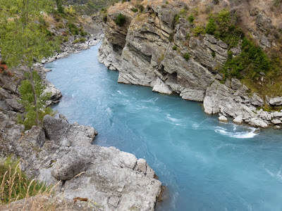
From the Kawarau we drove on back north, then northwest, then west across the Haast Pass, which we'd also seen in 2009. The giant montane lakes along the route, Lake Hawea and then Lake Wanaka, again, were impressive. Our campsite at Cameron Flat was scenic. The sand flies were more numerous and aggressive than we've seen anywhere but Milford. I'll do a separate post on sand flies, the South Island's largest bio-mass, a bit later.
Lake Hawea; giant, beautiful blue, almost no one in sight


Ditto


Ditto again


You round a corner and cross a little ridge, and there is Lake
Wanaka, another giant lake east of the Mt. Aspiring range,
one we've seen lots of before


We camped that night, along with one or two other parties, at the DOC campground
at Cameron Flat; scenic enough, but the sand flies were awful; the scores of them
trapped between out (nylon mesh) tent and its fly made such a racket we thought it
was raining


At the cooking pavilion that DOC campgrounds often provide, a spider's web
has netted half a dozen sand flies


In this amazing sequence, the spider (Shelob), devours one hapless sand fly


And then heads off to another


Vicki takes refuge in the car until nightfall, when the accursed sand flies go away

Monday, February 24, 2014

Kawarau Bridge, 2014

It's not a place you just drive by, even if you've seen it before. Rarely does a physical place so well manifest the nature of its people, the very soul, the raison d'etre, the whatever, of New Zealand, South Island, Otago, well, certain parts of Queenstown anyway. We had to go in, especially to see whether the gift shoppe had any clever new T-shirts or fridge magnets.
Old Kawarau Bridge, Birthplace of Bungy


The original launch site for AJ Hackett Bungy


Central hall of the reception/gift shoppe/museum/restaurant/multimedia
expo/wine tasting complex


New T-shirt, predictable design; STAY TUNED: I have a great
video of a young woman jumping off a bridge, to be posted on my
YouTube channel someday soon when we get decent wifi
again

Sunday, February 23, 2014

Anduin And The Argonath

Students of the Lore and fellow members of the Fellowship of the Ringwaifs will recall The Fellowship's voyage down the Great River, the Anduin, past the Argonaths. It's all north of Queenstown. We'd visited before, but it merits another look.
They're still there, blasted through by all the popular jet boat rides...


The Great River


Ditto


Ditto again


Along the north side cliffs is a vineyard of some note, from which we bought a
bottle in 2009; the Kiwi dollar was at .56USD back then...


And just a bit further down the river is one of New Zealand's great historic sites,
the original Kawarau Bridge, Birthplace of Bungy

Return To Arrowtown, 2014

From our encampment near Queenstown, we drove on to hyper-touristy Arrowtown, a gold-rush town we had visited in 2009, and had been impressed with, then. In 2014, it struck us--absent the LOTR sites we'd already seen--as quite touristy, with little redeeming merit but its "historic" "Chinatown." Lots of tour buses.
X marks the spot where a gold nugget was found, sparking off
one of the South Island's several gold rushes; it's interesting
how close New Zealand history is with that of the US West...fur,
whaling (where applicable), minerals, timber, abuse of the natives,
et al., livestock, now tourism


Actually, about the only thing that interested us in Arrowtown this time was the
Chinese settlement DOC has reconstructed


Imagine the tourists tossing coins in, wishing for good luck,
regularity, etc.


The usual...


Arrowtown main drag


Friday, February 21, 2014

Queenstown Again, 2014

So we left Te Anau about February 9, finished with the Fiordlands, and ready to head north. We stopped for a day in Queenstown, to shop for a few odds and ends (ask me about my All Blacks jersey deal) and also to walk through the old city park, which occupies a peninsula jutting out into the lake. Beautiful place.
But first, still in Te Anau, in time to see the Morgan Tour of
New Zealand, 2014; nice looking old cars...


And further still in Te Anau, a remembrance of things to
come...in a little more than two months we'll be setting up
house-keeping in Paris...


At the marina in Queenstown, the latest in contrived extreme
aquatic adventure


In the Queenstown city park


Looking back to the city center


The Robert Falcon Scott memorial (see the great old post-
WWII British film Scott of the Antarctic; listen to Vaughn
Williams' great Sinfonia Antarctica...)


Stirring the hearts of every Englishman....


Among many other things, the Queenstown city park has a
folf course...memories of Missoula


An horizontal elm in the large rose garden


Lawn bowling society command and control center


Pride of place, however, goes to the several
Cupressaceae California, Sequoiadendron
Gigantea Wellingtonia


Thus


And a grand old lady Monkey Puzzle, staple
of many a Victorian garden


We spent the night at a DOC campground on a lake in the
mountains a few miles west of Queenstown


Wednesday, February 12, 2014

Ascent of Mt. Luxmore, 2014

Mt. Luxmore is a bump on the ridge just off the Kepler Track, well above the Luxmore Hut. Not many people have climbed it twice, I suppose, but I had my reasons. I climbed it in 2009, while Vicki was elsewhere on the Kepler, and recorded--on this very blog--my time from Brod Bay to the Hut: 4 hours. I was curious, and concerned, to see if I could match that time five years later. The full ascent is probably close to 4,000 feet.
Actually, pretty much the whole ascent was in a white-out; Lake Te Anau was in
an inversion, owing to the (relatively) warm, dry weather


Along the hike, under a big head-wall


Once up on the plateau I figured the clouds had burned off; but no, I had just gotten
above them


Looking up toward Mt. Luxmore, the bump on the right


Looking around...various peaks poking through the clouds;it all looked pretty alpine,
if not Himalayan, despite the fact you're only about 3,000 feet up


Ditto


Ditto again


At the base of the trail up to the summit, two Kea conspire to distract me and
steal my wallet, keys, camera, etc.


Mt. Luxmore summit triangulation point; looking toward Lake Te Anau


Summit area


Summit selfie; compare with 2009: OK, I may have aged 5 years, but I have
definitely gotten better at self-portraits


Te Anau town through the clouds


Looking back, on the long tiresome descent


Luxmore Hut


Arrival of the grand-parents: a large extended family was having a reunion at the
hut, and here the grandparents arrive by helicopter (Rebecca and Rachel note)


Next morning, some higher clouds and a view of one of Lake
Te Anau's several glacial arms 


Last hazy look at Mt. Luxmore; I made the climb to the hut in 4 hours 11 minutes,
that is, 11 minutes off my 2009 pace; a dinner acquaintance, a marine biologist by
trade, said that was not statistically significant; so I was pleased...