Friday, February 13, 2009

It's a Pine; No, It's a Fir; No, It's a Spruce; No, Wait,

It's a National Park Service-Approved Cell Tower!

Another reason it's good to be back. Much as I have been impressed by New Zealand's Te Papa Atawhai (Department of Conservation)--and it is impressive--they have far, far less to address, culturally, naturally, and historically, than our own NPS. Despite it's ups and downs, ins and outs, backs and forths, and backs, I have held the NPS in the highest regard and affection ever since my first ranger-led hike, in 1970, in the Tetons. Getting to know NPS pros like Michael Ober, Deirdre Shaw, and Lyndel Meikle in recent years has only increased my esteem.


It's a National Park Service-Approved Cell Tower!

Do they decorate the "trees" at Xmas?

Thursday, February 12, 2009

Bear Left; Right, Frog*


Our new car is a Chevy Cobalt, newer and sportier than the Millennium Bongo, more fun to drive, but it has no bed. And let me take this opportunity to note and congratulate myself on driving some 3,500 accident-free kilometers in New Zealand, on the "proper" side of the road, as our Kiwi friends described it. I thought transitioning back to the "improper" side would be quick and easy, but alas, I find it is a set of habits that have to be deliberately re-acquired. Why can't turn signal and windshield wiper controls be standardized, as are accelerator and brakes, I ask?

*The Muppet Movie

Repatriation


Take-Off View of Diamond Head

Medium Island

Lekeleke Burial Grounds, Keauhou

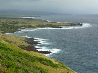
Kona Coast View

Welcome to Hawaii Volcanoes National Park; But You Can Drink the Water...

So far in our first 24 hours back in the States, we have done business with Mesa Airlines, Avis, Walmart, McDonald's, Tony Roma's, Safeway, and 7-11. We feel fully repatriated now. I guess the last time we were in a Walmart was...in Chongqing. We also went to a Tony Roma's in Shanghai.... Oh well. The American Way.

We're on the BIG Island now, in a cabin at Hawaii Volcanoes National Park. (Well, actually, at the lodge presently, for the free wifi). Rain has delayed our tenting. We hope it won't interfere with other plans. But we have all our rain gear, which served us well in Fiordland.

Tuesday, February 10, 2009

AKL-NRT-HNL

Auckland-Tokyo/Narita-Honolulu. Actually it's not as bad as it sounds. Or perhaps we have learned how to do this sort of thing: plenty of fluids, move around, have things to read or do (we mostly watched movies on one leg; slept on the other; I loved "Burn After Reading," watched it twice, made Vicki watch it). Despite the 11 hour trip to Tokyo, 3 hour layover, and then 6 hours to Honolulu, Auckland and Honolulu are only 4 hours apart, so we felt less jet-jagged than simply a bit fatigued. Then the adenalin kicks in. (Oh, we decided not to spend the few days originally scheduled in Japan; already been there, done that; very expensive). The flight to Tokyo was of special interest to this life-long WWII (the Big One) history buff. (I have actually read all of Samuel Eliot Morison's "History of US Naval Operations in WWII"; and some more too). We flew past the Coral Sea, all of northern New Guinea in the distance, the Solomon Islands (Vicki's dad was wounded at Guadalcanal in August, 1942), Bougainville, Rabaul off the left, Truk to the right, Guam and some of the Marianas. My exuberance was curbed appropriately insofar as we were nearly the only non-Japanese aboard. But it was great to see, even from 38,000 feet. The immigration officer at Honolulu noted our long absence and offered us a kind and sincere welcome back. It is good to be back in more ways than I can count. Vicki had found us a pretty nice $67 Waikiki hotel. She has a talent for this and, despite complaints, enjoys these little--some not so little--victories. How lucky am I? While she R&Rd, I had lunch with friend and former colleague Bob Buss, director of the Hawaii Humanities Council. It was good to talk to someone who was not a stranger, to get some real insight about the islands, and even to engage in a little "shoptalkqua." The HCH does some great things in a very special place. Things are moving along in the public humanities, as always, some of which I still miss very much (especially the people), and some not (alas, also people). Bob still climbs Diamond Head every morning. I took the bus back to the hotel. A local cabbie had taken me for a ride on the way out. The meter is no guarantee of honesty. We have ridden cabs in all seven of the nations we have visited, but were never ripped-off to this extent. Most cabbies we have encountered are relatively honest, or at least not overly greedy (and some we have extravagantly tipped for their honesty). It is a difficult way to make a living, with a very narrow profit margin. It was at least refreshing to get reliable and intelligble directions, and assistance, from the bus drivers, and in English, too (as the fella says). Tomorrow we fly to the Big Island for 8 days of sight-seeing, hiking, maybe snorkeling, etc., in a rental car, budget accommodations, even tent-camping (we have lugged our mountain tent around half the world and finally are going to use it!). Tonight (Monday), after a BBQ dinner and stroll in Waikiki we are checking email, and, of course, re-sorting and re-packing. More later.

Bob Buss Full Moon over Waikiki 

Sunday, February 8, 2009

Adieu, New Zealand

We're back in Auckland now, packing furiously for our 9:15 flight tomorrow morning to Tokyo, then after a brief lay-over at Narita, to Honolulu and a few weeks in the islands of Hawai'i. (According to United Airlines, New Zealand is part of Asia and thus our Asia Pass). Our flight from Dunedin today at least afforded a good look at Mt. Doom, there in the middle of the North Island, which we missed in the clouds at Xmas. Unfortunately, the pilot would not stop for us to toss in the Ring.

I am sure I'll be reflecting on New Zealand, like China, as long as I live, although for different reasons. We thoroughly enjoyed our time here, more than thoroughly, people, scenery, experiences. Of all the places we have visited, it is the one to which we will return first. I am sure I will write more about Kiwis and New Zealand again.


Vicki adds...February 9, 2009—Auckland

Today we gain back the day we lost last September. However, we spend it in the air. Ten hours from Auckland to Tokyo and then an unknown number to Honolulu. I can't even remember my last blog post. My knee has finally decided it has had all it can take of trekking or even walking, so I have had to be careful of it the last few days. So much for my theory that if I just exercised it a lot, it would return to youthful health.

We did buy a Big Island Lonely Planet guide in Dunedin and have enough info now to make rough plans. However culture shock is surely going to set in, especially with prices. Even budget rooms seem to be $100 a night. We did finally find rental cars that were reasonable. Maybe we will take this homeless stuff all the way and just sleep in the car. We do plan on trying tent camping at Volcano National Park—if it's not raining, that is. Backpacking tents aren't much fun in tropical rainstorms. Four weeks from today we will be back in Missoula. I am more excited about that then even seeing Kauai and Hawaii.

Speight's Brewery

Most important of the Dunedin sites we visted was Speight's Brewery. Even before deciding to go there, we noticed people queuing up just to draw free Speight's water from the deep old brewery well. Hey, if the water's that good, we wondered, what about the beer? See illustration. Speights is the great Southern beer (ale, lager, porter, etc.) of New Zealand. We skipped the brewery tour, of course, and headed directly for the brewery pub, for a lunch and sampler of the brews. See other illustrations. The sampler was most generous, each glass topped off, about 6 ounces per. Vicki had to help with the golden lager: her first beer ever! Rachel, be proud of your M. It was probably her last, too, however. She had the rib-eye sandwich and chips for lunch, and I had the porter sausage on mash with caramelized onions and gravy, washed down with porter and four other varieties. Hearty fare. We took another long walk through the CBD before I felt comfortable driving back out to the motor camp in Brighton, near the beach, where we spent our last night on the South Island.
Holy Water; There Was a Constant Flow
of People Filling All Manner of Jugs and
Other Containers


Porter Sausage on Mash with Onions and Gravy...
Hearty Fare, Indeed...But This Makes Me Wonder
Where the Expression "Hearty" Comes From...the
American Heart Association?
Unfortunately, that was about all she drank


Some of the pub interior

Some more


It's not a beer, it's a lifestyle, a
nationality


Done Edin


Yes, But Can You Buy a Bottle of Highland Park in This Town? Or a Tin of Rattray's Smoking Mixture?

The Old RR Station; Flemish As Well As Scottish Influence Here

Cadbury's: Another Tour We Eschewed

Saturday we drove back into Dunedin and did the town, visiting the Octagon, the obligatory Robbie Burns statue, the train station, and various other sites, modestly stimulating the local economy as we toured.

To Dunedin, Otago

The drive to Dunedin veered back inland most of the way, although it was not without interest, including the largest shoe-fence (or shoe-anything) I have ever seen. We have seen several shoe-fences in New Zealand, but this one takes the prize.

From Dunedin we continued out onto the Otago Peninsula, another 5 star world class sort of place that we thought was over-rated and over-priced. The main attraction is wildlife, most of which we have now seen, but especially the royal albatross breeding site. We went into the visitor center, watched the video, etc., but balked at the $40 charge to go on a tour where you get to see an albatross in its nest, being manipulated and exploited by humans. Hey, they are just big sea-going ducks as far as I can tell—they even quack, according to the soundtrack—and there are many varieties, few of which are endangered or even threatened. We walked the cliffs instead, hoping to see one in flight. Next time; maybe.

Dunedin accommodations were full; it was a big Maori national holiday and also the weekend Otago U students were coming back to campus, and also Chinese New Year, so we stayed at a motel in Mosgiel, on the geographical and cultural outskirts, and undertook the vast sorting and packing necessary for our flight Sunday to Auckland.
The Shoe Fence, more than 100m long; magnificent!

Seascapes

After the penguin encounter we drove around Molyneux Bay and up, on foot, mostly, to the 1870 lighthouse and its incredible views of the coast and rock platforms out in the sea. Seal and sealions were all around on the rocks below. Pretty incredible.

Huge cliff next to lighthouse

View from lighthouse

Sea lions, seals below

Penguins!


Penguins!

This One Just Emerged from the Sea

Drying-Off; Acclimatizing: We Can Relate...

Later, as dusk approached, we drove out to Nugget Point, in hopes of seeing that rarest and most endangered of penguins, the yellow-eyed penguin, from behind a DOC blind. Our patience, and yet another sand-fly encounter, was repaid extravagantly as we saw eight of them, three emerging onto the beach after a day's fishing in the sea. They surface, swim up to the beach, then stand there quite a while, allowing their bodies to adjust to the vast change in temperature. Then they climb up to their nests in the bush and feed regurgitated fish to their young. What a privilege to see them!

Saturday, February 7, 2009

The Catlins: Slope Point


Surf City; Click to Enlarge and See Surfers

Jurassic Log

Slope Point: As Far South As We Are Going

Slope Point, Stage Right

Stage Left

From Invercargill, we continued east along the Southern Scenic Route, throu Otara to Waipapa Point. Next was Curio Bay (surf's up), and Slope Point, the southernmost point of the New Zealand “mainland.” (We'll do some of islands some other time; maybe). It is not as deserted nor remote as Cape Reingal on the north end of the North Island. The nearby cliffs and crashing sea—the Antarctic Ocean? maps we have looked at are inconclusive—are much nearer. There are penguins about (see following posts), and that makes it Antarctic enough for us. At last we were (since Te Anau) closer to the South Pole than the Equator. At Curio Bay, among lots of other things, there is, at low tide, a fossil forest—scores of Jurassic trees that were petrified and then submerged with all the tectonic moving around.

We camped at Owaka (I think), and began the unpleasant task of eating-down the surplus of food, especially canned and freeze-dried, accumulated over the past two months. Our days in New Zealand now are numbered.

Henry the Tuatara

Southland Museum, Largest Pyramid in the Southern Hemisphere, the Book Said (built by Cheops III?) Henry; He Moved Twice While We Were Watching (this is most unusual)  
Henry Spawn The Southland Museum's main prize (other than some interesting exhibits on NZ's subantarctic islands, shipwrecks there, etc.) is a 120 year old Tuatara, Henry (see illustration). The Tuatara are a lizard remnant of the Jurrassic period, much reduced in size nowadays, but they are found on the subantarctic islands and even on the NZ mainland. Henry has recently mated (following an operation ("to his willy" the museum staffer said)) and a couple of his eleven new descendants also are pictured.

Friday, February 6, 2009

Bluff


The Road Does Not Go Ever On From Here

Bluff Deco

Bluff's Rubbish Centre (note decor)

Both Bluff and Invercargill are treated poorly in the "Footprints" guidebook we are using. We found both to be of interest, although, yes, Invercargill could use a few more trees in places. At Invercargill, we took in the Southland Museum (see following post). Bluff is out on the coast and is notable for being the southern terminus of route #1, the South Island's main highway. Some of the architecture was of interest, although most all of it faced the the giant alumininum plant across the harbor.

To Invercargill


Beach at Blue Cliffs

We packed up and left Te Anau Wednesday. It has beeen our base of operations for all three major tramps on the lower part of the island, and we have gotten to know it fairly well, especially the downtown strip, the supermarket, Fiordlands Cinema, and the small but wonderful Te Anau public library.

From Te Anau we took the “Southern Scenic Route” south. It is the only road, but it is generally scenic, especially if you like hills, grass and sheep. En route we viewed Lake Manipouri, Te Anau's big neighbor, saw Tuatapere, from which the cruises to Doubtful Sound depart (next time!), and stopped briefly at Blue Cliff Beach, from which the brand new Hump Ridge Tramp departs into the more inaccessible regions of Fiordlands. The beach at Blue Cliffs featured views of distant Stewart Island as well as the largest beach pebbles I have ever seen.

We drove on, finally reaching the south coast, and camped at a crummy holiday park near Invercargill beach. At least it was cheap.

Kepler Tramp: High Road/Low Road

We divided forces for the Kepler Tramp. Vicki's knees needed a lighter work-out and definitely not the 3,000 foot ascent to the Kepler's Luxmore Hut. So, on Tuesday, she did the lower, level part of the tramp, from Rainbow Reach to the Moturau Hut, over-nighting there, and returning to Te Anau on Wednesday. This is the third or last day of the tramp.

At the same time, I did the first day of the tramp, to Luxmore Hut, and ultimately, to Luxmore Summit, and back. I took the Kepler water taxi across the lake to save 5km and then started up the unrelenting climb to the hut. I have never seen such a trail. Never very steep, but always up, even the bridges. It was the standard, groomed DOC Great Walk track, gutters on both sides, wide enough to walk two-abreast, stair-cased in the steep or washed-out areas, then board-walked across the more sensitive parts of the tussock. I arrived at the hut a mere 4 hours after departure, just in time to see the heli landing, and 30 minutes less than the “standard” DOC posts at every track. (These standards are set by Hamish MacHaste, NZ's 1000 meter record holder).

After check-in and a quick lunch at the hut, I decided to continue on to the Luxmore summit. It was a fine if blustery day, but clouds and drizzle were predicted for the afternoon and next day. So, after lightening my pack a bit at the hut, I proceeded on the next mile or two, another 400 meters up, to the summit. The last bit was rocky outcrop, but even there was a discernible DOC path right to the top. The crux of the route was simply not getting blown off. I lingered, took a number of pix, and reflected with satisfaction on the 4,000 feet I had climbed between 9AM and 3 PM. I don't think I have covered that much altitude in a day since the 1980s. There was energy left, so, after a brief rest at the hut, I walked out to the Luxmore Cave, a nascent, unimproved (no trail, no lighting, no signage) cave, a hundred meters long, on Mt. Luxmore.

The evening featured pleasant conversation with a Munich couple whose travels the last several months closely tracked our own. They were in Agra and Pushkar when we were, also in Bangkok, also on the Abel Tasman, etc.

I got up early the next morning, hiked down quickly, caught the 9:30 water taxi back to Te Anau, and met Vicki at the library.


A DOC Heli Lands at Luxmore Hut Just as I Arrive

Luxmore Summit from the Kepler Track

Summit View Toward Te Anau

Self-Portrait

Sunday, February 1, 2009

Remedial Routeburn


Mirror Lakes; Click to Englarge and Read the Clever DOC Sign in the Center

Christina Peak, from Key Summit

Another Peak in the Vicinity

Aotearoa: The Land of the Long White Cloud

Sunday morning I took the TrackNet bus up from Te Anau up to the Divide to fetch the Bongo. It was a fine day, some high clouds, so from the Divide I hiked up to Key Summit, an off-shoot of the Routeburn, to see some of the things we missed on the first rainy down out.

Routeburn Tramp; Or, There and Back Again Via Bus

The Routeburn Track, another of New Zealand's “Great Walks,” encompasses parts of two national parks, Fiordlands and Mt. Aspiring, and, like most mountainous regions, there are places you can't get to from here. Whether you do the Routeburn east to west or west to east, you are still faced with a 350km ride, normally via bus, back to your starting point. Having already done the last day's part of the Routeburn as a day hike earlier in the month, we had hoped to avoid the bus trip with a little back-tracking. Thus, we thought we would do the first day from the Divide to Mackenzie Hut, then cross the pass and stay at Routeburn Falls Hut; and then, having already done the rest of the tramp, back-track to Mackenzie and then back out to the Divide, where the Bongo was parked. No bus ride. Clever. Except that the second day, Lake Mackenzie to Routeburn Falls, across the pass, was much harder than we anticipated. The Routeburn is a “moderate” track (not “easy”), and the pass section, virtually the whole second day, was rough alpine trail, not the groomed DOC track to which we have grown accustomed. It was particularly rough on Vicki's knees, which don't like the rockier alpine paths, boulders, downed trees, stream crossings, and such. Add to this it rained most of the first day and all of the second, and we saw little of the advertised alpine scenery. By the time we reached the Falls Hut late Friday afternoon, we had resolved to continue on to the track's end, an easier downhill trail to Routeburn Shelter, and do the bus return, via Queenstown, to Te Anau; and later, just me, back to the Divide to pick up the Bongo. We did get to see a bit of the alpine stuff, peaks and glaciers and such, on the way out, the third day. And despite the white-outs and rain, we saw some interesting sights the second day, a helicopter landing in the white-out, tarns, waterfalls, alpine flora, and so. Tree-line, bush-line here, is only about 1000m. (I observe, FWIW, that there are many bushes above bush-line, but no trees). And we met and broke bread with more nice people, lots of Kiwis, two Americans, two Canadians, a Finn and an Ozzie. The Ozzie explained the Oz thing about Australia to me. The beech forests were rather better on the Mt. Aspiring side, we thought, which we had already seen (Lothlorien), and it was noticeably drier there. Several streams and one big waterfall were already gone since our last walk, two weeks before. There also were no sand-flies on the east side. The Canadian couple, very experienced younger trekkers who were coming off both the Greenstone and Routeburn tramps, agreed that Alaskan mosquitoes were far preferable to Kiwi sand- flies. You can at least see the Alaskan bugs and occasionally bring one down. The highlight of the tramp, at least for me, was the very entertaining hut warden at Mackenzie, who gave us useful information about the granite worms and also about predicting local weather. “If you can see Mt. Dunston out that window, it will soon rain; if you can not see Mt. Dunston out that window, it is raining.” The bus rides from Routeburn Shelter to Te Anau afforded opportunities to briefly revisit Glenorchy, Lake Wakatipu, Queenstown (a lay-over), and Mossburn (the deer capital of New Zealand). Just north of Mossburn we were treated to a double rainbow. I had seen a triple rainbow before—in Missoula, of course—but the double was still unusual enough to be of interest. The bus and other tourist transportation in these parts, and throughout NZ, is excellent. Mostly it is private, but very affordable, and goes just about everywhere. In Fiordlands we have ridden TrackNet several times, all around Milford, Te Anau, and Queenstown. We met one Ozzie family that got off the four-day Milford Tramp at 2 PM, immediately caught the boat to Milford Sound, the 2:30 TrackNet bus back to Te Anau and then Queenstown airport for their flight back to Sydney that evening. They were perfectly confident of the connections, said they'd done this sort of thing many times. With enough time, one could really do most all of NZ without a car.

The Mackenzie Hut, Vicki Stepping Out into the Rain Earland Falls, 182m, and a Really Nasty Over-Hang Strangely, the Heli Was Not Visible in My Pix of Its Landing and Taking-Off in the White-Out at the Bottom of the Canyon The Drying Rack at Routeburn Falls Hut; Everyone Was Soaked On the Way to the Routeburn Shelter Double Rainbow Near Mossburn, From the Bus